Need well service in Stephenville?

DFW Well Service helps property owners with water well drilling, pump service, inspections, and related well issues across North Texas.

Welcome to Stephenville, TX — DFW Well Service serves Stephenville and Erath County

Water Well Drilling & Pump Repair in Stephenville, TX | DFW Well Service

Service Area Overview

Licensed well drilling and pump service in Stephenville, TX, reaching the Trinity aquifer's Paluxy and Twin Mountains sands; depth varies by parcel.

Services We Provide in Stephenville

DFW Well Service (TDLR License #61234 DKMPW) is a licensed well contractor serving Stephenville and Erath County with residential, ranch, and agricultural water well services.

Well Depth & Geology in Stephenville Area

Isometric geological cross-section cube illustration showing Erath County, Texas stratigraphy — Topsoil, Paluxy (Upper Trinity sand), Glen Rose (Middle Trinity), Twin Mountains (Lower Trinity basal sand), and the Trinity aquifer at the base.

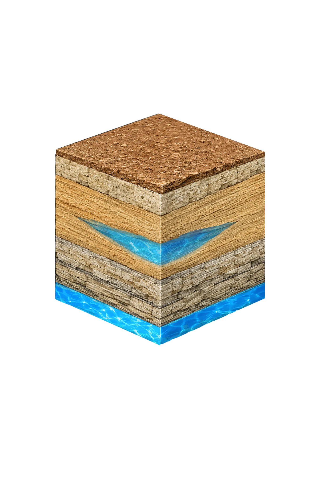
Tap any layer in the cube — or in the list below — to see what it is and what it means for drilling a well here.

  1. Topsoil — Post Oak / Cross Timbers
    0–20 ft
  2. Comanche Peak / Walnut limestone cap
    20–60 ft
  3. Paluxy (Upper Trinity sand)
    shallow to moderate where present
  4. Glen Rose (Middle Trinity)
    varies
Tap or hover a layer in the cube to see what's beneath the surface here.

This cross-section shows the layer stack typical of Erath County. The exact formations and depths under a specific Stephenville-area property vary — see the details above.

Explore the full Erath County geology →

Primary Aquifer
Trinity

Secondary: Brazos River Alluvium (TWDB minor aquifer)

Typical Well Depth
Varies by location

We estimate from nearby well records

Groundwater District
Middle Trinity GCD
Confinement
outcrop / near-outcrop transition county

Erath County overview → Permit & regulations → TDLR License #61234 DKMPW Updated June 4, 2026

Wells around Stephenville draw from the Trinity aquifer, and the city is also the headquarters of the Middle Trinity Groundwater Conservation District. The Trinity’s main sand layers here are the Paluxy nearer the surface and the deeper Twin Mountains basal sand; local and district planning materials also break the Trinity into several other named units (Glen Rose, Travis Peak, Hensell, Pearsall, Hosston, and — where the Glen Rose thins south of town — the Antlers), but for a homeowner it’s all one Trinity system. The strongest local depth anchor is the TWDB/MTGCD monitor well south of Stephenville on US Highway 281 (well #3155504): 332 feet deep, completed in the Twin Mountains sand, and tracked continuously since February 2000, with only about 11 feet of water-level decline over 26 years.

Erath County’s agricultural economy — particularly its dairy operations — creates demand for high-yield wells capable of sustaining large water draws. Standard residential wells are also common in the county, and Stephenville’s growing population includes both city residents and rural homeowners on private well systems.

Erath County Permit Requirements

All water wells in Stephenville and Erath County must be permitted through the Middle Trinity Groundwater Conservation District and TDLR. The Middle Trinity GCD requires a permit before drilling and a well completion report afterward. Agricultural wells may have additional yield-reporting requirements.

For more detail, see our guide to Erath County water well regulations.

Call DFW Well Service at (940) 536-8560 for a free estimate on any well project in the Stephenville area. We serve all of Erath County and are experienced with both the Middle Trinity GCD permit process and the area’s formation characteristics.

Frequently Asked Questions

What aquifer does Stephenville rely on?
Stephenville and Erath County draw their water from the Trinity aquifer. Wells complete in the Trinity's sand layers — the Paluxy nearer the surface and the deeper Twin Mountains basal sand — which provide reliable yields for homes, ranches, and farms across the area.
How deep are water wells in Stephenville?
There's no single typical depth across Erath County — it varies meaningfully from one property to the next, so we review the driller's logs from neighboring wells before quoting a project. One useful local anchor: the TWDB/MTGCD monitor well south of Stephenville on US Highway 281 (well #3155504) is 332 feet deep, completed in the Twin Mountains sand of the Trinity, and has been tracked continuously since February 2000 — showing only about 11 feet of water-level decline over 26 years, a sign of a stable aquifer here.
What permits are required for a well in Erath County?
Water wells in Erath County must be permitted through TDLR and the Middle Trinity Groundwater Conservation District before drilling begins. We manage the permit process and submit all required completion reports.
How much does well drilling cost near Stephenville?
Erath County drilling costs typically run $38–$50 per foot. Total cost depends on completion depth and the full system (casing, pump, pressure tank, electrical). We provide a free itemized written estimate after reviewing neighboring driller's logs for your parcel.
Do ranches and farms near Stephenville commonly use private wells?
Yes. Erath County is one of Texas's major dairy and cattle counties, and large-scale agricultural water use is common. Ranch and farm wells in this area often need to produce higher yields than standard residential wells to support livestock and irrigation needs.
Can you service wells near Tarleton State University rental properties?
We service well systems throughout the Stephenville area. If you own property — whether residential, rental, or commercial — that depends on a private well, we can handle drilling, pump service, inspection, and water testing.
Is the well water in Stephenville salty or brackish?
Generally no. Stephenville sits on or near the Trinity outcrop — the area where the aquifer reaches the surface — which the Texas Water Development Board maps as predominantly fresh; the brackish part of the Trinity lies farther east. Hardness, not salt, is the usual concern.

Request Service

Tell us about the property and what you need help with.

Fields marked * are required.