Planning a well in Denton County?

Water Well Drilling & Service in Denton County, Texas
Denton County sits over the Trinity (Paluxy / Glen Rose / Twin Mountains; Antlers in northern Denton County) aquifer system (confined; outcrop in far western Denton County). Most residential wells target the Woodbine Aquifer (eastern Denton County); depth varies meaningfully across the county and is best estimated from neighboring TWDB well records. Drilling is regulated by the North Texas GCD, which requires a pre-drilling permit. Local water quality consideration: Trinity water is typically hard, picking up calcium from the limestone it sits in.
What’s Under Denton County: a Layer-by-Layer Look
About this diagram
This cross-section shows the actual rock formations beneath Denton County, from topsoil down to the Trinity (Paluxy / Glen Rose / Twin Mountains; Antlers in northern Denton County) aquifer system.
Tap any layer in the image, or any layer in the list, to explore each layer and what it means for drilling a well on your property.
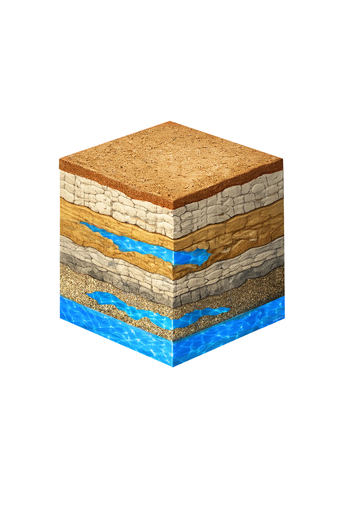
- Topsoil — Cross Timbers transition0–15 ft
- Comanche Peak / Walnut limestone15–80 ft
- Paluxy Formation80–250 ft
- Glen Rose Formation250–350 ft
- Twin Mountains Formation350–450 ft
Denton County stratigraphy — top to bottom
- Topsoil — Cross Timbers transition
- Brown-to-reddish loam in western Denton County grading to dark clay loam in the east — the expansive surface soil the well collar sits in.
- Comanche Peak / Walnut limestone
- Thin Comanche Peak / Walnut limestone and marl of the Fredericksburg cap above the Paluxy; low-permeability confining cover, not water-bearing.
- Paluxy Formation
- Upper Trinity sand and the primary target across central and western Denton County. Distinguishable in southern Denton County; in northern Denton County, where the Glen Rose is absent, it coalesces with the Twin Mountains into the Antlers Formation.
- Glen Rose Formation
- Gray-tan interbedded limestone and clay; present in southern Denton County and thinning to absence northward (TWDB Reports 269 and 318).
- Twin Mountains Formation
- Deep Trinity basal sand and the lower producing interval. In northern Denton County, where the Glen Rose is absent, the Paluxy and Twin Mountains coalesce into the Antlers Formation.
0–15 ft
15–80 ft
80–250 ft
250–350 ft
350–450 ft
Denton County stratigraphy — top to bottom
- Topsoil — Cross Timbers transition (0–15 ft)
- Brown-to-reddish loam in western Denton County grading to dark clay loam in the east — the expansive surface soil the well collar sits in.
- Comanche Peak / Walnut limestone (15–80 ft)
- Thin Comanche Peak / Walnut limestone and marl of the Fredericksburg cap above the Paluxy; low-permeability confining cover, not water-bearing.
- Paluxy Formation (80–250 ft)
- Upper Trinity sand and the primary target across central and western Denton County. Distinguishable in southern Denton County; in northern Denton County, where the Glen Rose is absent, it coalesces with the Twin Mountains into the Antlers Formation.
- Glen Rose Formation (250–350 ft)
- Gray-tan interbedded limestone and clay; present in southern Denton County and thinning to absence northward (TWDB Reports 269 and 318).
- Twin Mountains Formation (350–450 ft)
- Deep Trinity basal sand and the lower producing interval. In northern Denton County, where the Glen Rose is absent, the Paluxy and Twin Mountains coalesce into the Antlers Formation.
Denton County Quick Facts
- Primary Aquifer
- Trinity (Paluxy / Glen Rose / Twin Mountains; Antlers in northern Denton County)
- Typical Well Depth
- Varies by location
- Groundwater District
- North Texas GCD
- Confinement
- confined; outcrop in far western Denton County
Secondary: Woodbine (eastern Denton County)
We estimate from nearby well records
Water Quality Notes
- Trinity water is typically hard, picking up calcium from the limestone it sits in
- Iron can run high in some Paluxy zones
Cities We Serve in Denton County
Argyle, TX
Licensed well drilling and pump service on Argyle acreage properties in Denton County, reaching the Trinity aquifer's Paluxy and Twin Mountains sands.
View Argyle details →Sanger, TX
Licensed well drilling and pump service in Sanger and northern Denton County, reaching the Trinity aquifer's Antlers Formation sands.
View Sanger details →What's Under Denton County: the Geology Story
Drilling in Denton County means starting in topsoil, working through Local alluvium (Elm Fork of the Trinity, Ray Roberts and Lewisville lake margins), Woodbine Aquifer (eastern Denton County), Washita and Fredericksburg Groups, Paluxy Formation (Trinity upper unit), Glen Rose Formation (southern Denton County only), to reach the Twin Mountains Formation (southern Denton County) / Antlers Formation (northern Denton County) — the producing zone for most domestic wells.
The full layer-by-layer stratigraphy is laid out under the cube above. Well depth in Denton County varies by property location and overburden thickness; your driller can review TWDB records for neighboring wells to refine the expected completion zone before drilling.
Permits & Regulations in Denton County
Denton County wells are regulated by the North Texas GCD. A pre-drilling permit is required before any new well is constructed. DFW Well Service submits the permit application as part of our drilling process.
Full Denton County permit & regulations →Frequently Asked Questions about Denton County Wells
What aquifer is under Denton County?
How deep are wells typically drilled in Denton County?
What water quality issues are common in Denton County wells?
Does Denton County require a permit to drill a water well?
What's the main producing formation in Denton County?
Ready to drill or service a well in Denton County?
Most calls answered same business day. Licensed TDLR driller.
Request Well Service or a Drilling Estimate
Tell us a little about your property and what you need help with. We respond within a few hours during business hours.