Planning a well in Somervell County?
Water Well Drilling & Service in Somervell County, Texas
Somervell County sits over the Trinity (Glen Rose / Paluxy / basal Trinity sands — Hensell/Hosston PGCD planning names) aquifer system (outcrop — very shallow in places). Most residential wells target the Paluxy Formation; depth varies meaningfully across the county and is best estimated from neighboring TWDB well records. Drilling is regulated by the Prairielands GCD, which requires a pre-drilling permit.
What’s Under Somervell County: a Layer-by-Layer Look
About this diagram
This cross-section shows the actual rock formations beneath Somervell County, from topsoil down to the Trinity (Glen Rose / Paluxy / basal Trinity sands — Hensell/Hosston PGCD planning names) aquifer system.
Tap any layer in the image, or any layer in the list, to explore each layer and what it means for drilling a well on your property.
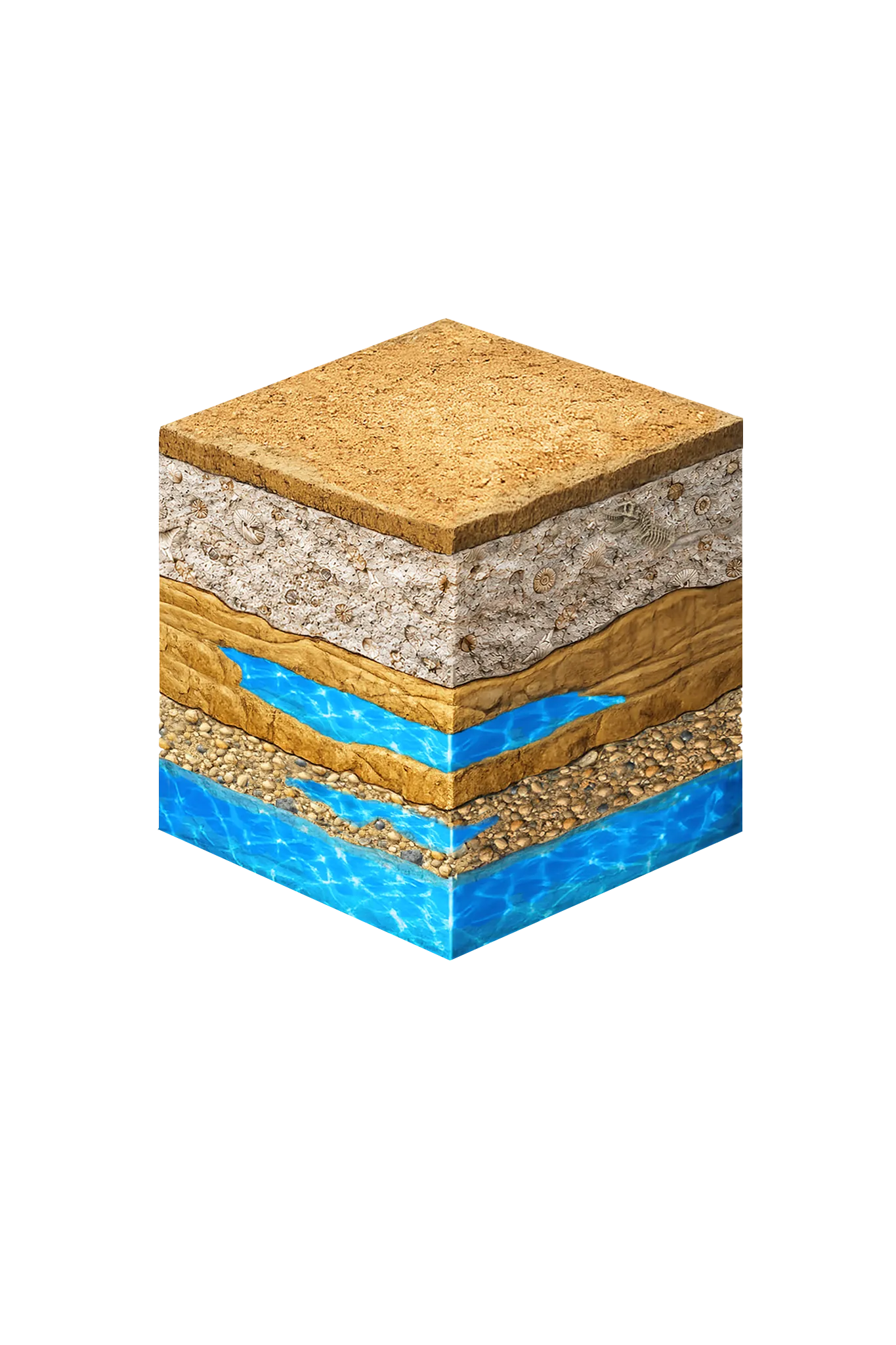
- Topsoil — Glen Rose outcrop0–10 ft
- Glen Rose Formation (at surface)10–200 ft
- Paluxy Formation200–400 ft
- Lower Trinity basal sand400–500 ft
Somervell County stratigraphy — top to bottom
- Topsoil — Glen Rose outcrop
- Thin rocky pale-tan soil over limestone full of cracks and sinkholes (karst), with cedar breaks.
- Glen Rose Formation (at surface)
- Pale gray fossil-bearing limestone right at the surface (an outcrop), including the dinosaur-track beds at Dinosaur Valley State Park — this is the worldwide reference site (type locality) for the Glen Rose, named for the town in Somervell County. A few shallow, small wells draw water from cracks and channels near its base, apparently fed by leakage from the Trinity below.
- Paluxy Formation
- A buff-tan sandstone, thin in Somervell County because the Glen Rose sits at or near the surface. It can be a target above the Glen Rose in places, but not consistently across the county.
- Lower Trinity basal sand
- The basal sands of the Trinity reservoir (PGCD: Hensell / Hosston; = Twin Mountains in north-central Texas terminology) — the most productive deeper Trinity unit when reached, providing artesian water at no great depth in the Glen Rose area.
0–10 ft
10–200 ft
200–400 ft
400–500 ft
Somervell County stratigraphy — top to bottom
- Topsoil — Glen Rose outcrop (0–10 ft)
- Thin rocky pale-tan soil over limestone full of cracks and sinkholes (karst), with cedar breaks.
- Glen Rose Formation (at surface) (10–200 ft)
- Pale gray fossil-bearing limestone right at the surface (an outcrop), including the dinosaur-track beds at Dinosaur Valley State Park — this is the worldwide reference site (type locality) for the Glen Rose, named for the town in Somervell County. A few shallow, small wells draw water from cracks and channels near its base, apparently fed by leakage from the Trinity below.
- Paluxy Formation (200–400 ft)
- A buff-tan sandstone, thin in Somervell County because the Glen Rose sits at or near the surface. It can be a target above the Glen Rose in places, but not consistently across the county.
- Lower Trinity basal sand (400–500 ft)
- The basal sands of the Trinity reservoir (PGCD: Hensell / Hosston; = Twin Mountains in north-central Texas terminology) — the most productive deeper Trinity unit when reached, providing artesian water at no great depth in the Glen Rose area.
Somervell County Quick Facts
- Primary Aquifer
- Trinity (Glen Rose / Paluxy / basal Trinity sands — Hensell/Hosston PGCD planning names)
- Typical Well Depth
- Varies by location
- Groundwater District
- Prairielands GCD
- Confinement
- outcrop — very shallow in places
Secondary: Brazos River Alluvium (TWDB minor aquifer)
We estimate from nearby well records
City We Serve in Somervell County
What's Under Somervell County: the Geology Story
Drilling in Somervell County means starting in topsoil, working through Brazos River alluvium (corridor only), Glen Rose Formation (at surface), Paluxy Formation, to reach the Basal Trinity sands (PGCD: Hensell / Hosston; = Twin Mountains in north-central Texas terminology) — the producing zone for most domestic wells.
The full layer-by-layer stratigraphy is laid out under the cube above. Well depth in Somervell County varies by property location and overburden thickness; your driller can review TWDB records for neighboring wells to refine the expected completion zone before drilling.
Permits & Regulations in Somervell County
Somervell County wells are regulated by the Prairielands GCD. A pre-drilling permit is required before any new well is constructed. DFW Well Service submits the permit application as part of our drilling process.
Full Somervell County permit & regulations →Frequently Asked Questions about Somervell County Wells
What aquifer is under Somervell County?
How deep are wells typically drilled in Somervell County?
Does Somervell County require a permit to drill a water well?
What's the main producing formation in Somervell County?
Ready to drill or service a well in Somervell County?
Most calls answered same business day. Licensed TDLR driller.
Request Well Service or a Drilling Estimate
Tell us a little about your property and what you need help with. We respond within a few hours during business hours.