Planning a well in Ellis County?
Water Well Drilling & Service in Ellis County, Texas
Ellis County sits over the Woodbine aquifer system (deep confined subcrop; ~100–1,400 ft beneath Ellis County). Most residential wells target the Woodbine Formation / Woodbine Aquifer; depth varies meaningfully across the county and is best estimated from neighboring TWDB well records. Drilling is regulated by the Prairielands GCD, which requires a pre-drilling permit. Local water quality consideration: A TWDB/BEG report puts the county's total dissolved solids (TDS, a measure of how mineral-heavy water is) from 310 mg/L in the alluvium to 3,040 mg/L in the Paluxy.
What’s Under Ellis County: a Layer-by-Layer Look
About this diagram
This cross-section shows the actual rock formations beneath Ellis County, from topsoil down to the Woodbine aquifer system.
Tap any layer in the image, or any layer in the list, to explore each layer and what it means for drilling a well on your property.
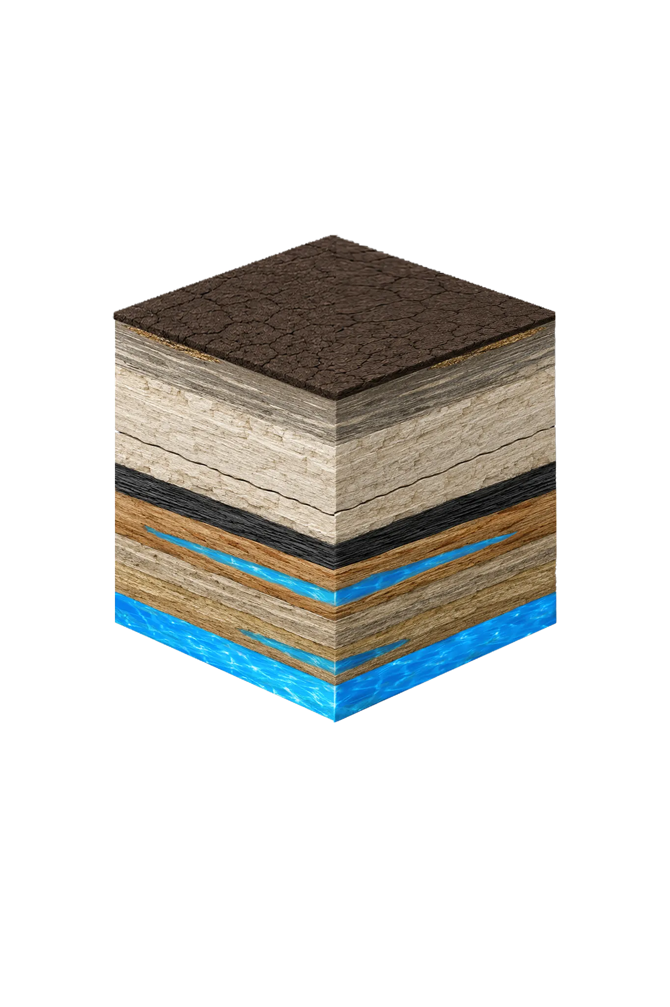
- Topsoil — Blackland Prairie (Houston Black)0–15 ft
- Austin Chalkvaries
- Eagle Ford Shalebelow Austin Chalk
- Woodbine Formation / Woodbine Aquifer100–1,400 (variable across county) ft
- Trinity Group: Paluxy / Glen Rose / Hensell / Hosston (= Twin Mountains)~2,000–3,000 (Hosston/Twin Mountains) ft
Ellis County stratigraphy — top to bottom
- Topsoil — Blackland Prairie (Houston Black)
- Dark black clay that swells and shrinks with moisture (shrink-swell).
- Austin Chalk
- Thick white chalky limestone — the near-surface bedrock across most of Ellis County. Where it is cracked or weathered it can carry a little shallow water, but that is site-specific and not a reliable household source.
- Eagle Ford Shale
- Dark gray organic shale; another regional seal that water does not pass through.
- Woodbine Formation / Woodbine Aquifer
- The main household water source in Ellis County. Its top ranges from about 100 ft to 1,400 ft across the county (a BEG report near the SSC site puts it at 600–1,000 ft there), so depth varies a lot by location. Wells usually finish in the lower part for cleaner water. The rock is medium-to-coarse iron-rich sandstone with clay and lignite (a soft coal) seams; TWDB Report 62 lists it as a principal Ellis County water-bearing formation.
- Trinity Group: Paluxy / Glen Rose / Hensell / Hosston (= Twin Mountains)
- The deep backup target, at roughly 2,000–3,000 ft beneath Ellis County. Going for it means real depth, and quality worsens enough eastward that the eastern third of the county rarely uses it. The Prairielands GCD names these Trinity layers Paluxy, Glen Rose, Hensell, and Hosston; the Hosston is the same sand called the Twin Mountains in north-central Texas.
0–15 ft
varies
below Austin Chalk
100–1,400 (variable across county) ft
~2,000–3,000 (Hosston/Twin Mountains) ft
Ellis County stratigraphy — top to bottom
- Topsoil — Blackland Prairie (Houston Black) (0–15 ft)
- Dark black clay that swells and shrinks with moisture (shrink-swell).
- Austin Chalk (varies)
- Thick white chalky limestone — the near-surface bedrock across most of Ellis County. Where it is cracked or weathered it can carry a little shallow water, but that is site-specific and not a reliable household source.
- Eagle Ford Shale (below Austin Chalk)
- Dark gray organic shale; another regional seal that water does not pass through.
- Woodbine Formation / Woodbine Aquifer (100–1,400 (variable across county) ft)
- The main household water source in Ellis County. Its top ranges from about 100 ft to 1,400 ft across the county (a BEG report near the SSC site puts it at 600–1,000 ft there), so depth varies a lot by location. Wells usually finish in the lower part for cleaner water. The rock is medium-to-coarse iron-rich sandstone with clay and lignite (a soft coal) seams; TWDB Report 62 lists it as a principal Ellis County water-bearing formation.
- Trinity Group: Paluxy / Glen Rose / Hensell / Hosston (= Twin Mountains) (~2,000–3,000 (Hosston/Twin Mountains) ft)
- The deep backup target, at roughly 2,000–3,000 ft beneath Ellis County. Going for it means real depth, and quality worsens enough eastward that the eastern third of the county rarely uses it. The Prairielands GCD names these Trinity layers Paluxy, Glen Rose, Hensell, and Hosston; the Hosston is the same sand called the Twin Mountains in north-central Texas.
Ellis County Quick Facts
- Primary Aquifer
- Woodbine
- Typical Well Depth
- Varies by location
- Groundwater District
- Prairielands GCD
- Confinement
- deep confined subcrop; ~100–1,400 ft beneath Ellis County
Secondary: Trinity (deep — Hosston/Twin Mountains at ~2,000–3,000 ft)
We estimate from nearby well records
Water Quality Notes
- A TWDB/BEG report puts the county's total dissolved solids (TDS, a measure of how mineral-heavy water is) from 310 mg/L in the alluvium to 3,040 mg/L in the Paluxy
- Most Paluxy, Woodbine, and Twin Mountains water here tops the EPA's 500 mg/L secondary TDS standard; only the alluvium stays below it
- Water is hard, picking up minerals from the limestone and chalk above
- Quality varies across the county — Midlothian and the northwest sit nearer where the aquifer surfaces and refills, while Ennis and the southeast lie farther downdip (deeper, where the layer tilts down), meaning deeper wells and more minerals
- Many Ellis County properties rely on city water rather than a private well
Cities We Serve in Ellis County
Ennis, TX
Licensed well drilling and pump service in Ennis and Ellis County. Woodbine is the primary residential aquifer; Trinity is deep here (downdip).
View Ennis details →Midlothian, TX
Licensed well drilling and pump service in Midlothian, TX. Woodbine is the primary Ellis County residential aquifer; Trinity is deep here.
View Midlothian details →Waxahachie, TX
Licensed well drilling and pump service in Waxahachie, TX. Woodbine is the primary Ellis County residential aquifer; Trinity is deep here.
View Waxahachie details →What's Under Ellis County: the Geology Story
Drilling in Ellis County means starting in topsoil, working through Quaternary alluvium / terrace (Trinity River, Chambers Creek), Taylor Group / younger Upper Cretaceous marl, chalk, and clay, Austin Chalk, Eagle Ford Shale, to reach the Woodbine Formation / Woodbine Aquifer — the producing zone for most domestic wells.
The full layer-by-layer stratigraphy is laid out under the cube above. Well depth in Ellis County varies by property location and overburden thickness; your driller can review TWDB records for neighboring wells to refine the expected completion zone before drilling.
Permits & Regulations in Ellis County
Ellis County wells are regulated by the Prairielands GCD. A pre-drilling permit is required before any new well is constructed. DFW Well Service submits the permit application as part of our drilling process.
Full Ellis County permit & regulations →Frequently Asked Questions about Ellis County Wells
What aquifer is under Ellis County?
How deep are wells typically drilled in Ellis County?
What water quality issues are common in Ellis County wells?
Does Ellis County require a permit to drill a water well?
What's the main producing formation in Ellis County?
Ready to drill or service a well in Ellis County?
Most calls answered same business day. Licensed TDLR driller.
Request Well Service or a Drilling Estimate
Tell us a little about your property and what you need help with. We respond within a few hours during business hours.