Planning a well in Wise County?

Water Well Drilling & Service in Wise County, Texas
Wise County sits over the Trinity (Antlers — Paluxy/Twin Mountains coalescence in central/northern Wise County; Paluxy/Glen Rose/Twin Mountains stack in southern Wise County) aquifer system (outcrop / shallow confined — Wise County sits on the geological boundary line where the Glen Rose Formation thins to extinction). Most residential wells target the Paluxy Formation (southern Wise County) / upper Antlers (central and northern Wise County); depth varies meaningfully across the county and is best estimated from neighboring TWDB well records. Drilling is regulated by the Upper Trinity GCD, which requires a pre-drilling permit. Local water quality consideration: Where the Trinity reaches the surface (its outcrop), the water is fresh but very hard, loaded with limestone-derived calcium carbonate.
What’s Under Wise County: a Layer-by-Layer Look
About this diagram
This cross-section shows the actual rock formations beneath Wise County, from topsoil down to the Trinity (Antlers — Paluxy/Twin Mountains coalescence in central/northern Wise County; Paluxy/Glen Rose/Twin Mountains stack in southern Wise County) aquifer system.
Tap any layer in the image, or any layer in the list, to explore each layer and what it means for drilling a well on your property.
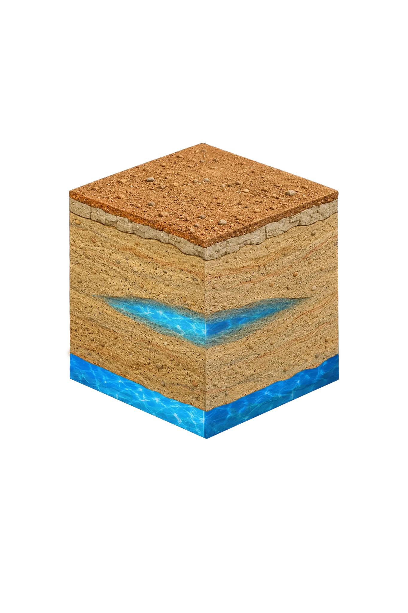

- Topsoil — West Cross Timbers0–20 ft
- Antlers Formationoutcrop / shallow confined — varies
Wise County stratigraphy — top to bottom
- Topsoil — West Cross Timbers
- Reddish-brown rocky sandy loam over rolling oak-and-mesquite terrain.
- Antlers Formation
- Single coalesced Trinity sand. In central and northern Wise County the Glen Rose Limestone is absent, so the Paluxy and Twin Mountains merge into one Antlers Formation — fine-to-coarse, cross-bedded sand and conglomerate and the principal residential producer; subcrop wells are generally more productive than outcrop wells (TWDB Report 269; Upper Trinity GCD 2023 Management Plan).
0–20 ft
outcrop / shallow confined — varies
Wise County stratigraphy — top to bottom
- Topsoil — West Cross Timbers (0–20 ft)
- Reddish-brown rocky sandy loam over rolling oak-and-mesquite terrain.
- Antlers Formation (outcrop / shallow confined — varies)
- Single coalesced Trinity sand. In central and northern Wise County the Glen Rose Limestone is absent, so the Paluxy and Twin Mountains merge into one Antlers Formation — fine-to-coarse, cross-bedded sand and conglomerate and the principal residential producer; subcrop wells are generally more productive than outcrop wells (TWDB Report 269; Upper Trinity GCD 2023 Management Plan).
Wise County Quick Facts
- Primary Aquifer
- Trinity (Antlers — Paluxy/Twin Mountains coalescence in central/northern Wise County; Paluxy/Glen Rose/Twin Mountains stack in southern Wise County)
- Typical Well Depth
- Varies by location
- Groundwater District
- Upper Trinity GCD
- Confinement
- outcrop / shallow confined — Wise County sits on the geological boundary line where the Glen Rose Formation thins to extinction
Secondary: Cross Timbers Aquifer (Pennsylvanian/Permian — significant in west-central Wise County)
We estimate from nearby well records
Water Quality Notes
- Where the Trinity reaches the surface (its outcrop), the water is fresh but very hard, loaded with limestone-derived calcium carbonate
- Some western Wise County zones produce iron from the upper Paluxy
Cities We Serve in Wise County
Boyd, TX
Licensed well drilling and pump service in Boyd, TX, reaching Wise County's Trinity aquifer (Paluxy and Twin Mountains sands); depth varies by parcel.
View Boyd details →Decatur, TX
Licensed well drilling and pump service throughout Decatur, TX, reaching the Trinity aquifer's Antlers Formation in central Wise County.
View Decatur details →Paradise, TX
Licensed well drilling and pump service in Paradise and rural Wise County, reaching the Trinity aquifer for ranch and residential customers.
View Paradise details →Rhome, TX
Licensed well drilling and pump service in Rhome and throughout rural Wise County, reaching the Trinity aquifer's limestone formations.
View Rhome details →What's Under Wise County: the Geology Story
Drilling in Wise County means starting in topsoil, working through Alluvial deposits (localized along major drainages), Comanche Peak / Walnut limestone cap, Paluxy Formation (southern Wise County) / upper Antlers (central and northern Wise County), Glen Rose Formation (eastern Wise County only), to reach the Twin Mountains Formation (southern Wise County) / lower Antlers (central and northern Wise County) — the producing zone for most domestic wells.
The full layer-by-layer stratigraphy is laid out under the cube above. Well depth in Wise County varies by property location and overburden thickness; your driller can review TWDB records for neighboring wells to refine the expected completion zone before drilling.
Permits & Regulations in Wise County
Wise County wells are regulated by the Upper Trinity GCD. A pre-drilling permit is required before any new well is constructed. DFW Well Service submits the permit application as part of our drilling process.
Full Wise County permit & regulations →Frequently Asked Questions about Wise County Wells
What aquifer is under Wise County?
How deep are wells typically drilled in Wise County?
What water quality issues are common in Wise County wells?
Does Wise County require a permit to drill a water well?
What's the main producing formation in Wise County?
Ready to drill or service a well in Wise County?
Most calls answered same business day. Licensed TDLR driller.
Request Well Service or a Drilling Estimate
Tell us a little about your property and what you need help with. We respond within a few hours during business hours.