Planning a well in Kaufman County?
Water Well Drilling & Service in Kaufman County, Texas
Kaufman County sits over the Limited groundwater — three distinct scenarios aquifer system (no single countywide aquifer; alluvium where present, deep Woodbine in western Kaufman County only, and deep brackish Trinity). Most residential wells target the Woodbine Group; depth varies meaningfully across the county and is best estimated from neighboring TWDB well records. Kaufman County sits outside all groundwater conservation districts — TDLR standards govern. Local water quality consideration: Groundwater in Kaufman County is limited and very location-dependent.
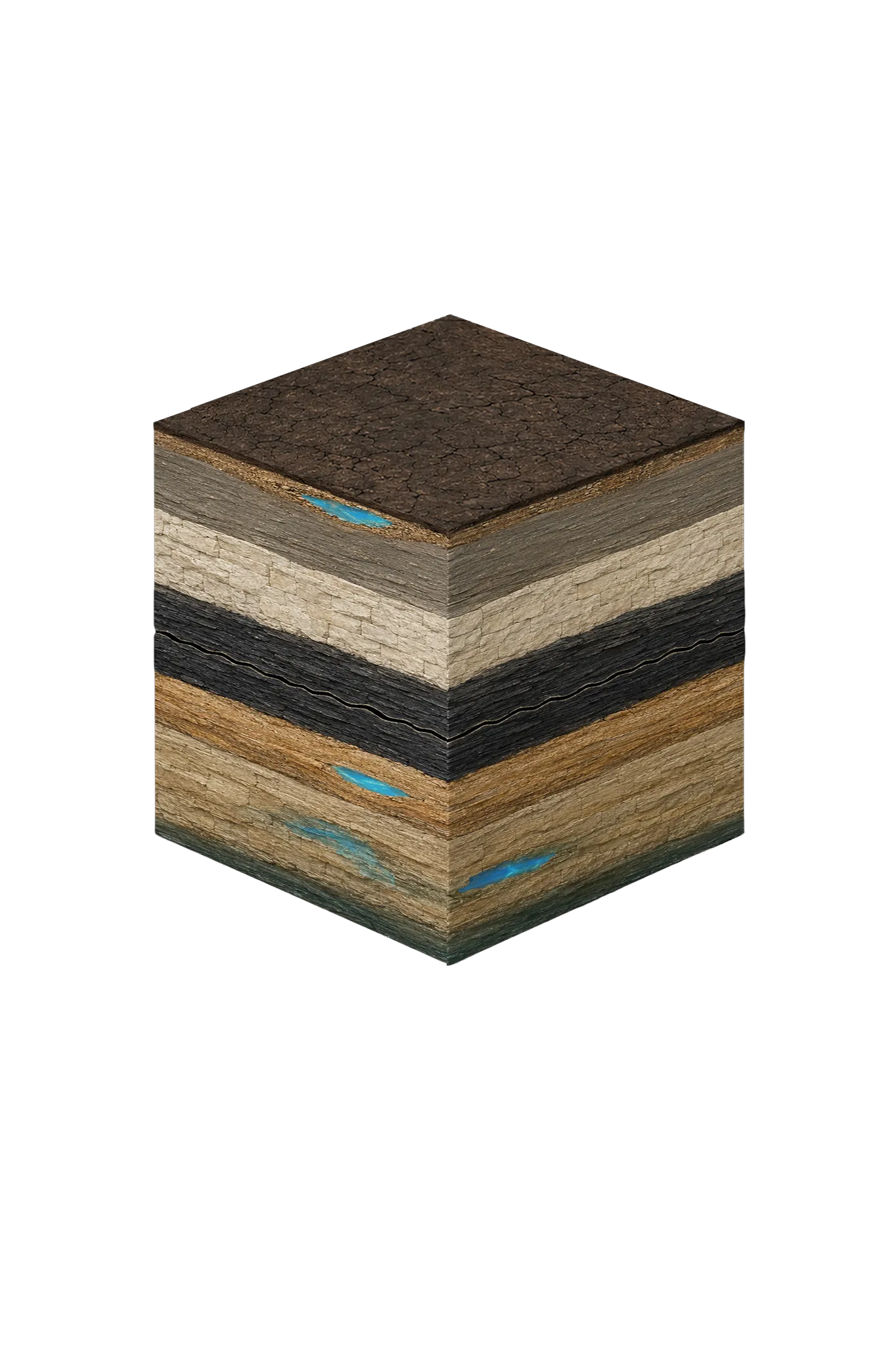
What’s Under Kaufman County: a Layer-by-Layer Look
About this diagram
This cross-section shows the actual rock formations beneath Kaufman County, from topsoil down to the Limited groundwater — three distinct scenarios aquifer system.
Tap any layer in the image, or any layer in the list, to explore each layer and what it means for drilling a well on your property.

- Topsoil — Blackland Prairie (Houston Black)0–15 ft
- Trinity River / East Fork Trinity alluvium (localized only)30–80 (where present) ft
- Taylor Groupvaries
- Austin Chalk / Eagle Fordbelow Taylor
- Woodbine Group600–1,200 (western only) ft
- Trinity Group (Paluxy, Glen Rose, Twin Mountains)2,500–3,500+ ft
Kaufman County stratigraphy — top to bottom
- Topsoil — Blackland Prairie (Houston Black)
- Dark black clay that swells and shrinks with moisture (shrink-swell).
- Trinity River / East Fork Trinity alluvium (localized only)
- Shallow sand and gravel along the major rivers — the most practical shallow source where it exists, but the yield is seasonal and surface-contamination risk is high. Site-specific only.
- Taylor Group
- Marl and lime-rich clay at the surface across much of the county; it produces no usable water.
- Austin Chalk / Eagle Ford
- Chalk, limestone, and shale beneath the surface layers; not dependable water sources.
- Woodbine Group
- A minor underground water source. In western Kaufman County it is projected at roughly 600–1,200 ft and may be usable near Forney, though quality worsens as you go east.
- Trinity Group (Paluxy, Glen Rose, Twin Mountains)
- Deep, sealed-in (confined), and brackish at this depth — projected at roughly 2,500–3,500+ ft and not a routine home target.
0–15 ft
30–80 (where present) ft
varies
below Taylor
600–1,200 (western only) ft
2,500–3,500+ ft
Kaufman County stratigraphy — top to bottom
- Topsoil — Blackland Prairie (Houston Black) (0–15 ft)
- Dark black clay that swells and shrinks with moisture (shrink-swell).
- Trinity River / East Fork Trinity alluvium (localized only) (30–80 (where present) ft)
- Shallow sand and gravel along the major rivers — the most practical shallow source where it exists, but the yield is seasonal and surface-contamination risk is high. Site-specific only.
- Taylor Group (varies)
- Marl and lime-rich clay at the surface across much of the county; it produces no usable water.
- Austin Chalk / Eagle Ford (below Taylor)
- Chalk, limestone, and shale beneath the surface layers; not dependable water sources.
- Woodbine Group (600–1,200 (western only) ft)
- A minor underground water source. In western Kaufman County it is projected at roughly 600–1,200 ft and may be usable near Forney, though quality worsens as you go east.
- Trinity Group (Paluxy, Glen Rose, Twin Mountains) (2,500–3,500+ ft)
- Deep, sealed-in (confined), and brackish at this depth — projected at roughly 2,500–3,500+ ft and not a routine home target.
Kaufman County Quick Facts
- Primary Aquifer
- Limited groundwater — three distinct scenarios
- Typical Well Depth
- Varies by location
- Groundwater District
- No GCD — TDLR standards only
- Confinement
- no single countywide aquifer; alluvium where present, deep Woodbine in western Kaufman County only, and deep brackish Trinity
We estimate from nearby well records
Water Quality Notes
- Groundwater in Kaufman County is limited and very location-dependent
- Western Kaufman County around Forney is the most plausible place for a private well, while the east (Terrell and beyond) is very limited
- Total dissolved solids (TDS, how mineral-heavy water is) climb with depth in the Trinity, and the county falls within TWDB's brackish Northern Trinity study area — brackish meaning slightly salty water that needs treatment
- Where the Woodbine can be reached, its water is often high in iron and manganese
- Shallow wells in the river-laid sand and gravel (alluvium) near the Trinity River and East Fork carry real risks from surface contamination, septic systems, and farm runoff
Cities We Serve in Kaufman County
Forney, TX
Water well drilling in Forney and Kaufman County. No GCD; TDLR rules apply. Limited-groundwater county where private wells need site-specific evaluation.
View Forney details →Terrell, TX
Water well drilling and pump repair in Terrell and Kaufman County. No GCD; TDLR standards apply. Very limited groundwater; site-specific evaluation needed.
View Terrell details →What's Under Kaufman County: the Geology Story
Drilling in Kaufman County means starting in topsoil, working through Trinity River / East Fork Trinity alluvium (localized only), Taylor Group, Austin Chalk / Eagle Ford, to reach the Woodbine Group — the producing zone for most domestic wells.
Kaufman County has no single straightforward home aquifer — it has three very different situations. Shallow river-corridor alluvium runs about 30–80 ft where it exists. A deeper Woodbine, roughly 600–1,200 ft, is only really usable in the west around Forney. And a deep, brackish, confined Trinity (sealed under rock) sits at a projected 2,500–3,500+ ft, which is not a routine home target. Eastern Kaufman County, from Terrell eastward, is capped by Taylor Group clay with every water-bearing layer deeper still, so options there are very limited. For most properties here, the realistic water source is treated city water on an NTMWD-connected system. Before you budget for a well, talk to a licensed driller and review nearby well logs for your specific tract.
The full layer-by-layer stratigraphy is laid out under the cube above. Well depth in Kaufman County varies by property location and overburden thickness; your driller can review TWDB records for neighboring wells to refine the expected completion zone before drilling.
Permits & Regulations in Kaufman County
Kaufman County sits outside all groundwater conservation districts. TDLR well construction standards govern, and your driller must be TDLR-licensed.
Full Kaufman County permit & regulations →Frequently Asked Questions about Kaufman County Wells
What aquifer is under Kaufman County?
How deep are wells typically drilled in Kaufman County?
What water quality issues are common in Kaufman County wells?
Does Kaufman County require a permit to drill a water well?
What's the main producing formation in Kaufman County?
Ready to drill or service a well in Kaufman County?
Most calls answered same business day. Licensed TDLR driller.
Request Well Service or a Drilling Estimate
Tell us a little about your property and what you need help with. We respond within a few hours during business hours.