Planning a well in Tarrant County?
Water Well Drilling & Service in Tarrant County, Texas
Tarrant County sits over the Trinity (Paluxy / Twin Mountains, separated by Glen Rose confining unit) aquifer system (deep confined across most of Tarrant County; limited Trinity outcrop in the far northwestern corner). Most residential wells target the Paluxy Formation (Trinity upper unit); depth varies meaningfully across the county and is best estimated from neighboring TWDB well records. Drilling is regulated by the Northern Trinity GCD, which requires a pre-drilling permit. Local water quality consideration: The Northern Trinity GCD reports Woodbine water measured above 1,500 mg/L total dissolved solids (TDS, how mineral-heavy water is) in the district.
What’s Under Tarrant County: a Layer-by-Layer Look
About this diagram
This cross-section shows the actual rock formations beneath Tarrant County, from topsoil down to the Trinity (Paluxy / Twin Mountains, separated by Glen Rose confining unit) aquifer system.
Tap any layer in the image, or any layer in the list, to explore each layer and what it means for drilling a well on your property.
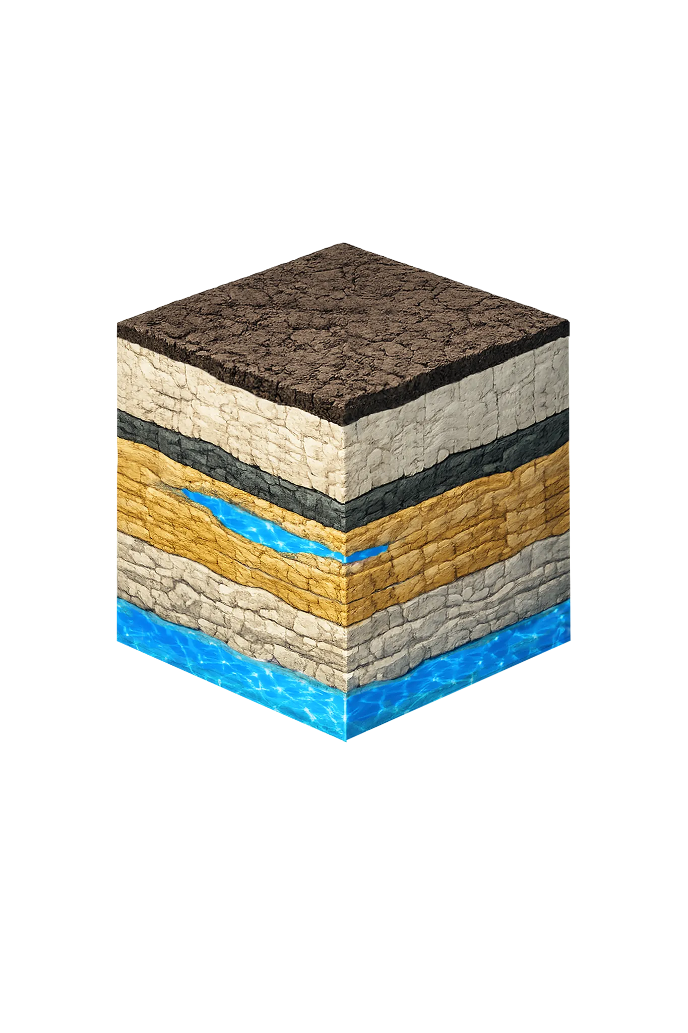
- Topsoil — Blackland Prairie / urban context0–10 ft
- Austin Chalk10–250 ft
- Eagle Ford Shale250–300 ft
- Paluxy Formation300–600 ft
- Glen Rose Formation600–800 ft
Tarrant County stratigraphy — top to bottom
- Topsoil — Blackland Prairie / urban context
- Dark gray-black clay that swells and shrinks with moisture (shrink-swell).
- Austin Chalk
- Austin Chalk — chalk and limestone above the Eagle Ford; a confining unit, not a primary domestic aquifer in Tarrant County.
- Eagle Ford Shale
- Eagle Ford Shale — dark calcareous shale; a confining unit between the chalk and the Woodbine/Paluxy section.
- Paluxy Formation
- Sand, silt, and clay with fine-grained sand dominant — sandstones make up more than 60% of the aquifer except in the northwest corner. The primary Trinity target; depth ranges from surface to roughly 1,000 ft, increasing eastward (NTGCD).
- Glen Rose Formation
- Acts mainly as a confining layer between the Paluxy and the Twin Mountains in Tarrant County.
0–10 ft
10–250 ft
250–300 ft
300–600 ft
600–800 ft
Tarrant County stratigraphy — top to bottom
- Topsoil — Blackland Prairie / urban context (0–10 ft)
- Dark gray-black clay that swells and shrinks with moisture (shrink-swell).
- Austin Chalk (10–250 ft)
- Austin Chalk — chalk and limestone above the Eagle Ford; a confining unit, not a primary domestic aquifer in Tarrant County.
- Eagle Ford Shale (250–300 ft)
- Eagle Ford Shale — dark calcareous shale; a confining unit between the chalk and the Woodbine/Paluxy section.
- Paluxy Formation (300–600 ft)
- Sand, silt, and clay with fine-grained sand dominant — sandstones make up more than 60% of the aquifer except in the northwest corner. The primary Trinity target; depth ranges from surface to roughly 1,000 ft, increasing eastward (NTGCD).
- Glen Rose Formation (600–800 ft)
- Acts mainly as a confining layer between the Paluxy and the Twin Mountains in Tarrant County.
Tarrant County Quick Facts
- Primary Aquifer
- Trinity (Paluxy / Twin Mountains, separated by Glen Rose confining unit)
- Typical Well Depth
- Varies by location
- Groundwater District
- Northern Trinity GCD
- Confinement
- deep confined across most of Tarrant County; limited Trinity outcrop in the far northwestern corner
Secondary: Woodbine (eastern Tarrant County only)
We estimate from nearby well records
Water Quality Notes
- The Northern Trinity GCD reports Woodbine water measured above 1,500 mg/L total dissolved solids (TDS, how mineral-heavy water is) in the district
- Woodbine yields are much lower and the water generally poorer — higher iron and manganese — than the Trinity layers in Tarrant County
- Per TWDB, the lower Woodbine zones yield the most water while the upper zone yields little and runs high in iron; the water is fresh to about 1,500 ft of well depth and slightly to moderately salty below that
City We Serve in Tarrant County
What's Under Tarrant County: the Geology Story
Drilling in Tarrant County means starting in topsoil, working through Quaternary alluvium (Trinity River corridor), Eagle Ford (undifferentiated), Woodbine Aquifer (eastern Tarrant County), Washita Group (Grayson, Mainstreet, PawPaw, Weno, Denton, Fort Worth, Duck Creek), Fredericksburg Group (Kiamichi, Edwards, Comanche Peak, Walnut), Paluxy Formation (Trinity upper unit), Glen Rose Formation, to reach the Twin Mountains Formation (with Hensell, Pearsall, Hosston subdivisions) — the producing zone for most domestic wells.
The full layer-by-layer stratigraphy is laid out under the cube above. Well depth in Tarrant County varies by property location and overburden thickness; your driller can review TWDB records for neighboring wells to refine the expected completion zone before drilling.
Permits & Regulations in Tarrant County
Tarrant County wells are regulated by the Northern Trinity GCD. A pre-drilling permit is required before any new well is constructed. DFW Well Service submits the permit application as part of our drilling process.
Full Tarrant County permit & regulations →Frequently Asked Questions about Tarrant County Wells
What aquifer is under Tarrant County?
How deep are wells typically drilled in Tarrant County?
What water quality issues are common in Tarrant County wells?
Does Tarrant County require a permit to drill a water well?
What's the main producing formation in Tarrant County?
Ready to drill or service a well in Tarrant County?
Most calls answered same business day. Licensed TDLR driller.
Request Well Service or a Drilling Estimate
Tell us a little about your property and what you need help with. We respond within a few hours during business hours.