Planning a well in Palo Pinto County?

Water Well Drilling & Service in Palo Pinto County, Texas
Palo Pinto County sits over the Cross Timbers Aquifer (Pennsylvanian) aquifer system (Pennsylvanian bedrock; water in fractures and localized sand and limestone lenses). Most residential wells target the Pennsylvanian Canyon Group at 100–450 feet. Palo Pinto County sits outside all groundwater conservation districts — TDLR standards govern. Local water quality consideration: Cross Timbers groundwater quality varies a lot; most sampled wells are fresh to slightly salty, with median total dissolved solids (TDS, how mineral-heavy water is) around 839 mg/L, though chloride runs about twice the typical Trinity level.
What’s Under Palo Pinto County: a Layer-by-Layer Look
About this diagram
This cross-section shows the actual rock formations beneath Palo Pinto County, from topsoil down to the Cross Timbers Aquifer (Pennsylvanian) aquifer system.
Tap any layer in the image, or any layer in the list, to explore each layer and what it means for drilling a well on your property.
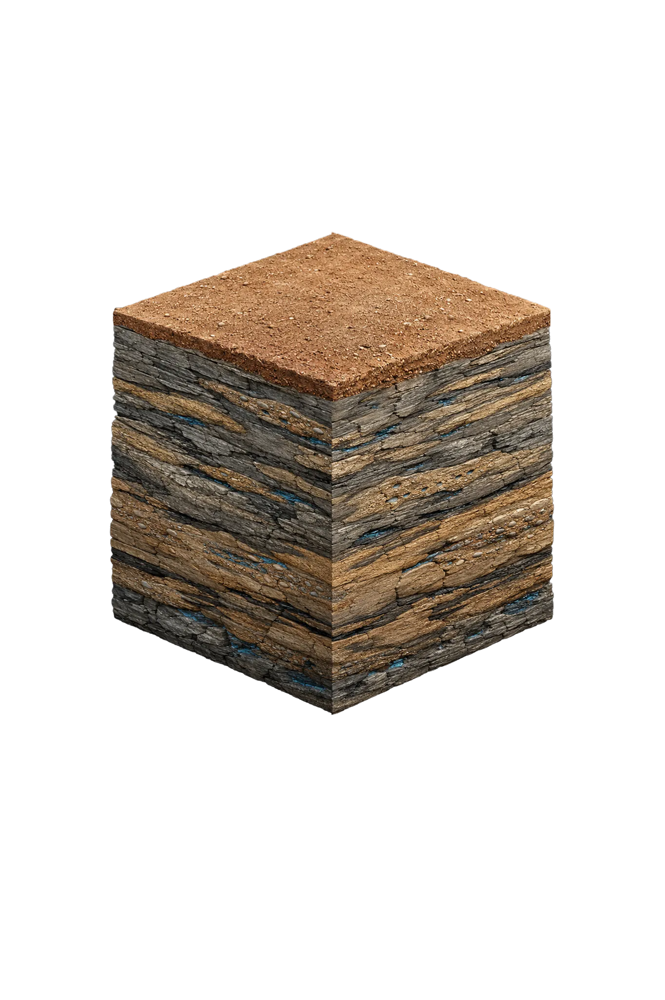
- Topsoil — Cross Timbers0–15 ft
- Pennsylvanian Canyon Group (limestone, shale, sandstone/conglomerate lenses)15–250 ft
- Pennsylvanian Strawn Group (sandstone, conglomerate, shale, thin coal)250–450 ft
Palo Pinto County stratigraphy — top to bottom
- Topsoil — Cross Timbers
- Thin rocky reddish-brown soil over rolling mesquite-and-cedar terrain.
- Pennsylvanian Canyon Group (limestone, shale, sandstone/conglomerate lenses)
- Pennsylvanian-age limestone interbedded with shale and thin sandstone and conglomerate. Part of the Cross Timbers Aquifer — water comes from fractures and localized sand and limestone lenses rather than a continuous sand, so yields are modest and patchy and dry holes occur (TWDB Cross Timbers Aquifer Report GMR19-01).
- Pennsylvanian Strawn Group (sandstone, conglomerate, shale, thin coal)
- Pennsylvanian-age sandstone, conglomerate, and shale with thin coal beds. The sandstone and conglomerate members carry water within the Cross Timbers Aquifer; yields vary widely and there is no clean base within residential drilling range (TWDB Cross Timbers Aquifer Report GMR19-01).
0–15 ft
15–250 ft
250–450 ft
Palo Pinto County stratigraphy — top to bottom
- Topsoil — Cross Timbers (0–15 ft)
- Thin rocky reddish-brown soil over rolling mesquite-and-cedar terrain.
- Pennsylvanian Canyon Group (limestone, shale, sandstone/conglomerate lenses) (15–250 ft)
- Pennsylvanian-age limestone interbedded with shale and thin sandstone and conglomerate. Part of the Cross Timbers Aquifer — water comes from fractures and localized sand and limestone lenses rather than a continuous sand, so yields are modest and patchy and dry holes occur (TWDB Cross Timbers Aquifer Report GMR19-01).
- Pennsylvanian Strawn Group (sandstone, conglomerate, shale, thin coal) (250–450 ft)
- Pennsylvanian-age sandstone, conglomerate, and shale with thin coal beds. The sandstone and conglomerate members carry water within the Cross Timbers Aquifer; yields vary widely and there is no clean base within residential drilling range (TWDB Cross Timbers Aquifer Report GMR19-01).
Palo Pinto County Quick Facts
- Primary Aquifer
- Cross Timbers Aquifer (Pennsylvanian)
- Typical Well Depth
- 100–450 ft
- Groundwater District
- No GCD — TDLR standards only
- Confinement
- Pennsylvanian bedrock; water in fractures and localized sand and limestone lenses
Secondary: Thin Trinity remnant on the far eastern edge (often brackish; not a routine target)
Water Quality Notes
- Cross Timbers groundwater quality varies a lot; most sampled wells are fresh to slightly salty, with median total dissolved solids (TDS, how mineral-heavy water is) around 839 mg/L, though chloride runs about twice the typical Trinity level
- Water can be hard with elevated iron and manganese, and wells finished in the Strawn Group occasionally hit stray gas or methane
- Recommended tests for any well: coliform bacteria, nitrates, total dissolved solids, chloride, hardness, iron, and manganese — plus a stray-gas check if finishing in the Strawn Group
City We Serve in Palo Pinto County
What's Under Palo Pinto County: the Geology Story
Drilling in Palo Pinto County means starting in topsoil, working through Pennsylvanian Canyon Group, to reach the Pennsylvanian Strawn Group — the producing zone for most domestic wells.
Palo Pinto County is geologically unlike the rest of the service area. The bedrock is Pennsylvanian — older than the Cretaceous Trinity that supplies most of the region — and the Trinity here is largely eroded away, surviving only as a thin, often brackish (slightly salty) remnant on the far eastern edge. Your water comes from the Cross Timbers Aquifer: scattered sandstone, conglomerate, and fractured limestone rather than one continuous layer. Yields are usually modest and dry holes turn up in tighter shale areas, so review nearby well logs before you budget for a well.
The full layer-by-layer stratigraphy is laid out under the cube above. Well depth in Palo Pinto County varies by property location and overburden thickness; your driller can review TWDB records for neighboring wells to refine the expected completion zone before drilling.
Permits & Regulations in Palo Pinto County
Palo Pinto County sits outside all groundwater conservation districts. TDLR well construction standards govern, and your driller must be TDLR-licensed.
Full Palo Pinto County permit & regulations →Frequently Asked Questions about Palo Pinto County Wells
What aquifer is under Palo Pinto County?
How deep are wells typically drilled in Palo Pinto County?
What water quality issues are common in Palo Pinto County wells?
Does Palo Pinto County require a permit to drill a water well?
What's the main producing formation in Palo Pinto County?
Ready to drill or service a well in Palo Pinto County?
Most calls answered same business day. Licensed TDLR driller.
Request Well Service or a Drilling Estimate
Tell us a little about your property and what you need help with. We respond within a few hours during business hours.