Planning a well in Cooke County?

Water Well Drilling & Service in Cooke County, Texas
Cooke County sits over the Trinity (Antlers) aquifer system (outcrop / subcrop). Most residential wells target the Antlers Formation (Trinity); depth varies meaningfully across the county and is best estimated from neighboring TWDB well records. Drilling is regulated by the North Texas GCD, which requires a pre-drilling permit.
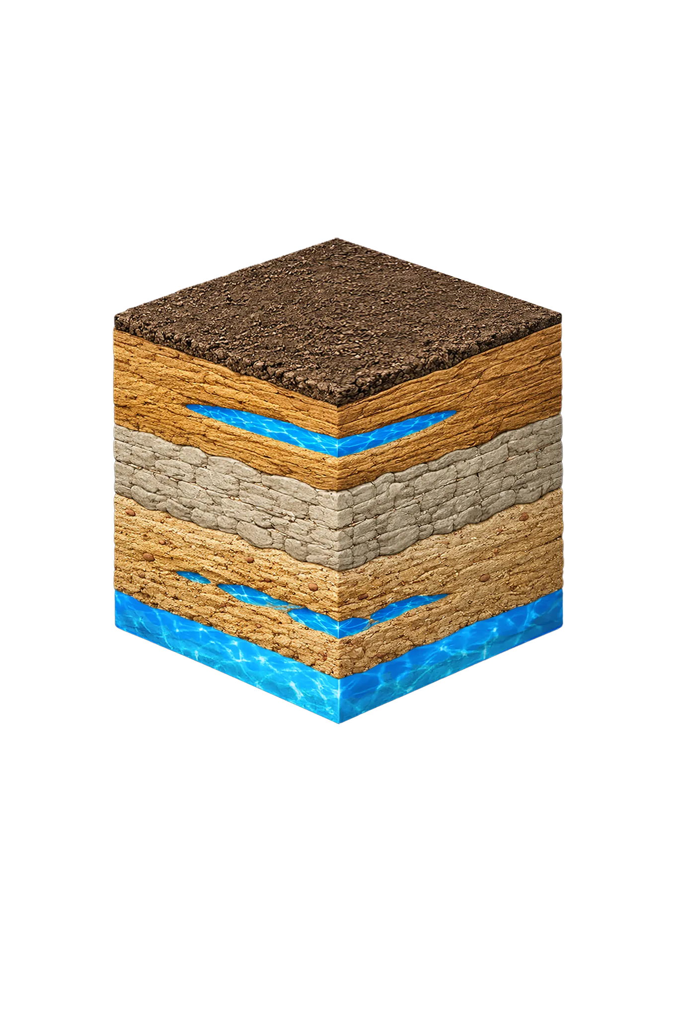
What’s Under Cooke County: a Layer-by-Layer Look
About this diagram
This cross-section shows the actual rock formations beneath Cooke County, from topsoil down to the Trinity (Antlers) aquifer system.
Tap any layer in the image, or any layer in the list, to explore each layer and what it means for drilling a well on your property.

- Topsoil — Post Oak Savanna transition0–15 ft
- Woodbine Group / Woodbine Aquifershallow — outcrop central/east
- Washita and Fredericksburg Groups (confining units)below Woodbine where present
- Antlers Formation (Trinity)outcrop west; deeper southeast
Cooke County stratigraphy — top to bottom
- Topsoil — Post Oak Savanna transition
- Sandy reddish-brown topsoil with scattered gravel.
- Woodbine Group / Woodbine Aquifer
- The county's secondary water source. It reaches the surface — the outcrop — in a north-south band through central and eastern Cooke County. Water is generally good in the lower two zones down to about 1,500 ft, then deteriorates quickly below that. The rock is sandstone layered with shale and clay.
- Washita and Fredericksburg Groups (confining units)
- Limestone, marl, and shale that seal off water rather than carry it (confining units). They have eroded away in western Cooke County.
- Antlers Formation (Trinity)
- The county's main water source. Where it reaches the surface — mainly in western and northwestern Cooke County — wells are shallower; to the southeast it dips beneath younger rock and wells go deeper. It is the Paluxy and Twin Mountains sands merged into one body (geologists call that merged unit the Antlers, because the Glen Rose Limestone is missing across Cooke County), up to 900 ft thick with clay beds through the middle.
0–15 ft
shallow — outcrop central/east
below Woodbine where present
outcrop west; deeper southeast
Cooke County stratigraphy — top to bottom
- Topsoil — Post Oak Savanna transition (0–15 ft)
- Sandy reddish-brown topsoil with scattered gravel.
- Woodbine Group / Woodbine Aquifer (shallow — outcrop central/east)
- The county's secondary water source. It reaches the surface — the outcrop — in a north-south band through central and eastern Cooke County. Water is generally good in the lower two zones down to about 1,500 ft, then deteriorates quickly below that. The rock is sandstone layered with shale and clay.
- Washita and Fredericksburg Groups (confining units) (below Woodbine where present)
- Limestone, marl, and shale that seal off water rather than carry it (confining units). They have eroded away in western Cooke County.
- Antlers Formation (Trinity) (outcrop west; deeper southeast)
- The county's main water source. Where it reaches the surface — mainly in western and northwestern Cooke County — wells are shallower; to the southeast it dips beneath younger rock and wells go deeper. It is the Paluxy and Twin Mountains sands merged into one body (geologists call that merged unit the Antlers, because the Glen Rose Limestone is missing across Cooke County), up to 900 ft thick with clay beds through the middle.
Cooke County Quick Facts
- Primary Aquifer
- Trinity (Antlers)
- Typical Well Depth
- Varies by location
- Groundwater District
- North Texas GCD
- Confinement
- outcrop / subcrop
Secondary: Woodbine
We estimate from nearby well records
City We Serve in Cooke County
What's Under Cooke County: the Geology Story
Drilling in Cooke County means starting in topsoil, working through Local alluvium along Red River and major streams, Woodbine Group / Woodbine Aquifer, Washita and Fredericksburg Groups (confining units), to reach the Antlers Formation (Trinity) — the producing zone for most domestic wells.
The full layer-by-layer stratigraphy is laid out under the cube above. Well depth in Cooke County varies by property location and overburden thickness; your driller can review TWDB records for neighboring wells to refine the expected completion zone before drilling.
Permits & Regulations in Cooke County
Cooke County wells are regulated by the North Texas GCD. A pre-drilling permit is required before any new well is constructed. DFW Well Service submits the permit application as part of our drilling process.
Full Cooke County permit & regulations →Frequently Asked Questions about Cooke County Wells
What aquifer is under Cooke County?
How deep are wells typically drilled in Cooke County?
Does Cooke County require a permit to drill a water well?
What's the main producing formation in Cooke County?
Ready to drill or service a well in Cooke County?
Most calls answered same business day. Licensed TDLR driller.
Request Well Service or a Drilling Estimate
Tell us a little about your property and what you need help with. We respond within a few hours during business hours.