Need well service in Gainesville?

DFW Well Service helps property owners with water well drilling, pump service, inspections, and related well issues across North Texas.

Welcome to Gainesville, TX — DFW Well Service serves Gainesville and Cooke County

Water Well Drilling & Pump Repair in Gainesville, TX | DFW Well Service

Service Area Overview

DFW Well Service is headquartered in Gainesville — our home base. We drill and service Cooke County wells under North Texas GCD.

DFW Well Service is proud to call Gainesville home. As a locally owned and operated well drilling and pump service company headquartered in Gainesville, TX, we know Cooke County’s groundwater, geology, and regulatory landscape better than anyone. Whether you’re drilling a new well on a rural acreage property, replacing a worn-out pump, or getting a well inspected before a real estate transaction, you’ll get local expertise and a fast response from our Gainesville team.

Services We Provide in Gainesville

Well Depth & Geology in the Gainesville Area

Isometric geological cross-section cube illustration showing Cooke County, Texas stratigraphy — Topsoil, Local alluvium along Red River and major streams, Washita and Fredericksburg Groups (confining units), Antlers Formation (Trinity), and the Trinity (Antlers) aquifer at the base.

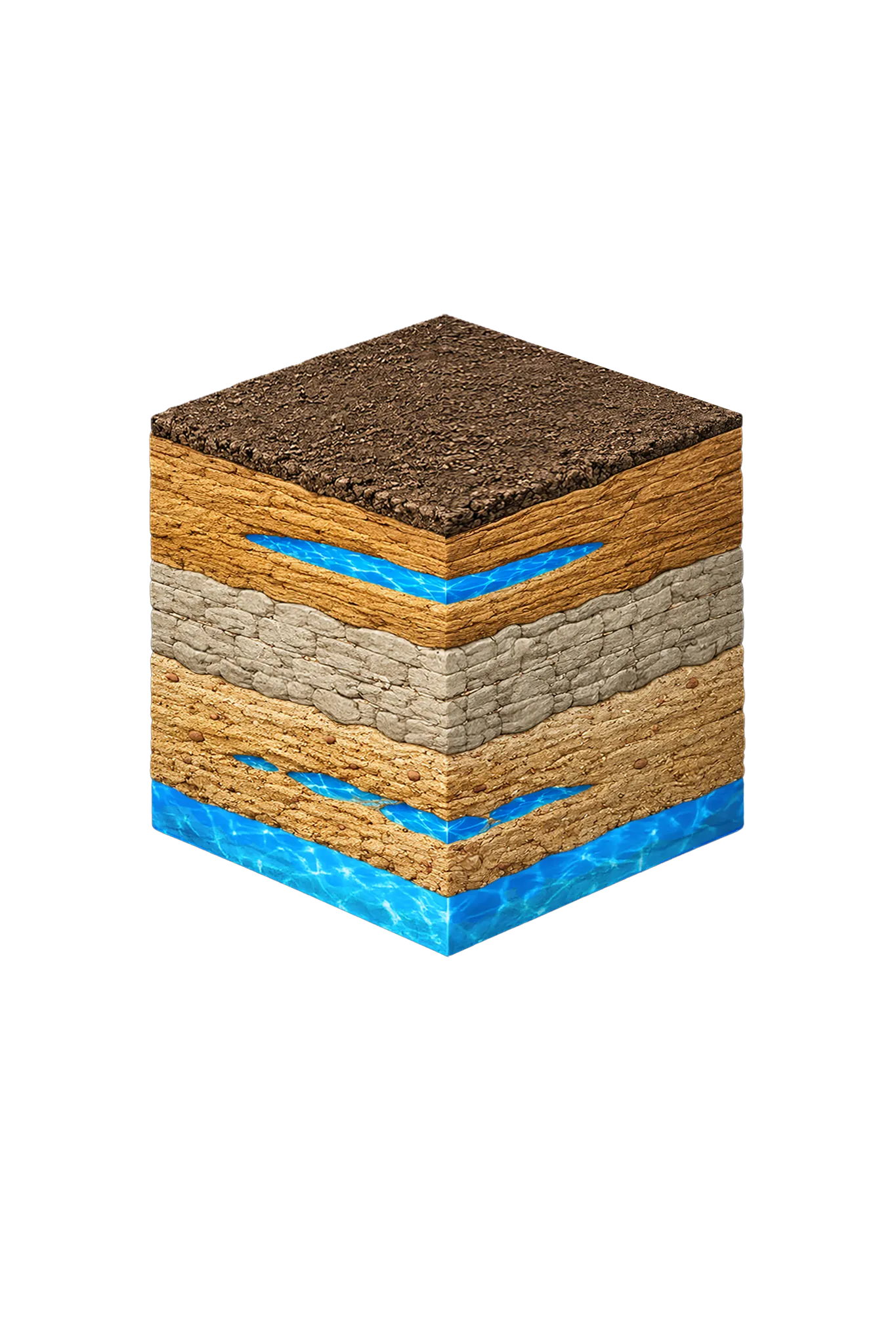
Tap any layer in the cube — or in the list below — to see what it is and what it means for drilling a well here.

  1. Topsoil — Post Oak Savanna transition
    0–15 ft
  2. Woodbine Group / Woodbine Aquifer
    shallow — outcrop central/east
  3. Washita and Fredericksburg Groups (confining units)
    below Woodbine where present
  4. Antlers Formation (Trinity)
    outcrop west; deeper southeast
Tap or hover a layer in the cube to see what's beneath the surface here.

This cross-section shows the layer stack typical of Cooke County. The exact formations and depths under a specific Gainesville-area property vary — see the details above.

Explore the full Cooke County geology →

Primary Aquifer
Trinity (Antlers)

Secondary: Woodbine

Typical Well Depth
Varies by location

We estimate from nearby well records

Groundwater District
North Texas GCD
Confinement
outcrop / subcrop

Cooke County overview → Permit & regulations → TDLR License #61234 DKMPW Updated June 4, 2026

Wells around Gainesville draw from two layers: the Woodbine sand nearer the surface and the deeper Antlers sand of the Trinity. Gainesville sits mostly on the Woodbine outcrop, where that sand reaches the surface. Beneath the county the Glen Rose limestone is absent, so the Trinity’s Paluxy and Twin Mountains sands merge into the single unit called the Antlers, which underlies the Woodbine at depth. A home well here completes in the Woodbine where it’s present and productive, or in the Antlers beneath it. (The area’s older Trinity public-supply wells have shown significant long-term water-level decline since the 1930s.)

Drilling costs in Cooke County run on the more affordable end of our service area thanks to manageable shallow-Woodbine drilling in many places.

Cooke County Permit Requirements

New wells in Cooke County require a pre-drilling permit through the North Texas Groundwater Conservation District. As a local driller, we work with the NTGCD regularly and are familiar with their process and requirements. For more on Cooke County permitting, see our guide to Cooke County water well regulations.

You won’t find a better-positioned well service company for Gainesville and Cooke County than DFW Well Service (TDLR License #61234 DKMPW). Call (940) 536-8560 — we’re right here in town.

Frequently Asked Questions

Is DFW Well Service based in Gainesville?
Yes. Gainesville is our home base. DFW Well Service is a locally owned well drilling and pump service company headquartered in Gainesville, TX. We serve Cooke County and the surrounding region, and our team lives and works here. When you call us for service in Gainesville, you get the fastest response time in our service area.
Which groundwater district covers Gainesville?
Gainesville and Cooke County fall under the North Texas Groundwater Conservation District (NTGCD). A pre-drilling permit is required for new wells. Because we're local and work with the NTGCD regularly, we know the process well and can move efficiently through permitting.
How deep are water wells in Gainesville?
There's no single typical depth around Gainesville — it varies meaningfully by parcel, so we review the driller's logs from neighboring wells before quoting a project. Gainesville sits mostly on the Woodbine outcrop (where that sand layer reaches the surface), and beneath the county the Glen Rose limestone is absent, so the Trinity's Paluxy and Twin Mountains sands merge into one layer called the Antlers. One caution: the old municipal and industrial Trinity wells around Gainesville ran 840–1,025 feet deep, but those are public-supply wells — a home well shouldn't be planned around those depths.
What does well drilling cost in Gainesville?
Cooke County drilling rates run on the more affordable end of our service area thanks to relatively manageable shallow-Woodbine drilling in many places. Final cost depends on completion depth, casing, pump, and pressure equipment. Call us for a precise estimate after we review neighboring driller's logs for your parcel.
How quickly can you respond to a pump emergency in Gainesville?
Being locally based means we can often respond to pump emergencies in Gainesville same-day or next-day. If you wake up with no water, call us first thing and we'll do everything we can to get you back in service quickly.
Do you drill irrigation and livestock wells in Cooke County?
Yes. In addition to domestic wells, we're equipped to drill irrigation and livestock wells for agricultural properties throughout Cooke County. Larger-capacity wells for irrigation and stock tanks require non-exempt permits through the NTGCD, and we manage that process for you.
Is the well water in Gainesville salty or brackish?
Usually not in the zones home wells use. The Woodbine around Gainesville is fresh through its outcrop band (where the sand reaches the surface) down to about 1,500 feet, and the Antlers Trinity sand is fresh where it surfaces to the west. Water turns saltier with depth and toward the southeast, per Texas Water Development Board mapping, so it's worth testing total dissolved solids (a measure of how mineral-heavy the water is) on deeper wells.

Request Service

Tell us about the property and what you need help with.

Fields marked * are required.