Planning a well in Erath County?
Water Well Drilling & Service in Erath County, Texas
Erath County sits over the Trinity aquifer system (outcrop / near-outcrop transition county). Most residential wells target the Paluxy (Upper Trinity sand); depth varies meaningfully across the county and is best estimated from neighboring TWDB well records. Drilling is regulated by the Middle Trinity GCD, which requires a pre-drilling permit.
What’s Under Erath County: a Layer-by-Layer Look
About this diagram
This cross-section shows the actual rock formations beneath Erath County, from topsoil down to the Trinity aquifer system.
Tap any layer in the image, or any layer in the list, to explore each layer and what it means for drilling a well on your property.
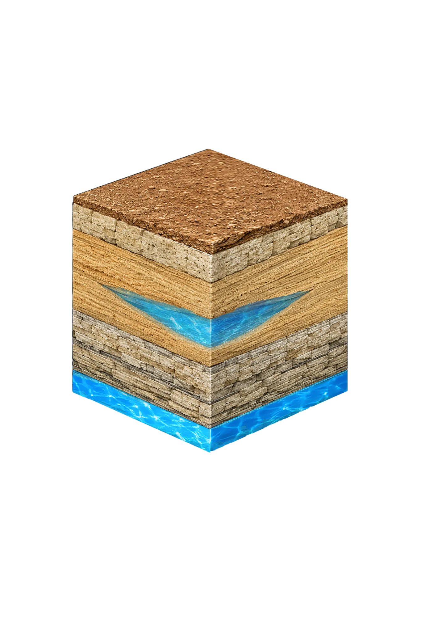
- Topsoil — Post Oak / Cross Timbers0–20 ft
- Comanche Peak / Walnut limestone cap20–60 ft
- Paluxy (Upper Trinity sand)shallow to moderate where present
- Glen Rose (Middle Trinity)varies
Erath County stratigraphy — top to bottom
- Topsoil — Post Oak / Cross Timbers
- Reddish-brown sandy loam over rolling terrain.
- Comanche Peak / Walnut limestone cap
- Thin Comanche Peak / Walnut limestone and marl cap above the Paluxy; low permeability and non-water-bearing — part of the confining cover the well passes through before reaching Trinity sand.
- Paluxy (Upper Trinity sand)
- An upper Trinity sand, shallow to moderate depth where present. It supplies only a small share of the county's Trinity water — the district's modeled available groundwater (MAG, the amount the state plans can be pumped) for it is 61 acre-ft/yr. The rock is fine-to-coarse sand layered with clay and shale.
- Glen Rose (Middle Trinity)
- Mostly limestone with shale and marl. It can be thin updip — nearer the surface where the layer is shallow — and where it is missing the Paluxy and Twin Mountains merge into the Antlers Formation. District MAG: 1,078 acre-ft/yr.
0–20 ft
20–60 ft
shallow to moderate where present
varies
Erath County stratigraphy — top to bottom
- Topsoil — Post Oak / Cross Timbers (0–20 ft)
- Reddish-brown sandy loam over rolling terrain.
- Comanche Peak / Walnut limestone cap (20–60 ft)
- Thin Comanche Peak / Walnut limestone and marl cap above the Paluxy; low permeability and non-water-bearing — part of the confining cover the well passes through before reaching Trinity sand.
- Paluxy (Upper Trinity sand) (shallow to moderate where present)
- An upper Trinity sand, shallow to moderate depth where present. It supplies only a small share of the county's Trinity water — the district's modeled available groundwater (MAG, the amount the state plans can be pumped) for it is 61 acre-ft/yr. The rock is fine-to-coarse sand layered with clay and shale.
- Glen Rose (Middle Trinity) (varies)
- Mostly limestone with shale and marl. It can be thin updip — nearer the surface where the layer is shallow — and where it is missing the Paluxy and Twin Mountains merge into the Antlers Formation. District MAG: 1,078 acre-ft/yr.
Erath County Quick Facts
- Primary Aquifer
- Trinity
- Typical Well Depth
- Varies by location
- Groundwater District
- Middle Trinity GCD
- Confinement
- outcrop / near-outcrop transition county
Secondary: Brazos River Alluvium (TWDB minor aquifer)
We estimate from nearby well records
Cities We Serve in Erath County
Dublin, TX
Licensed well drilling and pump service in Dublin, TX, reaching the Erath County Trinity aquifer; depth varies by parcel.
View Dublin details →Stephenville, TX
Licensed well drilling and pump service in Stephenville, TX, reaching the Trinity aquifer's Paluxy and Twin Mountains sands; depth varies by parcel.
View Stephenville details →What's Under Erath County: the Geology Story
Drilling in Erath County means starting in topsoil, working through Quaternary alluvium along Brazos River drainage (Bosque River, Leon River), Paluxy (Upper Trinity sand), Glen Rose (Middle Trinity), to reach the Twin Mountains (Lower Trinity basal sand) — the producing zone for most domestic wells.
The full layer-by-layer stratigraphy is laid out under the cube above. Well depth in Erath County varies by property location and overburden thickness; your driller can review TWDB records for neighboring wells to refine the expected completion zone before drilling.
Permits & Regulations in Erath County
Erath County wells are regulated by the Middle Trinity GCD. A pre-drilling permit is required before any new well is constructed. DFW Well Service submits the permit application as part of our drilling process.
Full Erath County permit & regulations →Frequently Asked Questions about Erath County Wells
What aquifer is under Erath County?
How deep are wells typically drilled in Erath County?
Does Erath County require a permit to drill a water well?
What's the main producing formation in Erath County?
Ready to drill or service a well in Erath County?
Most calls answered same business day. Licensed TDLR driller.
Request Well Service or a Drilling Estimate
Tell us a little about your property and what you need help with. We respond within a few hours during business hours.