Planning a well in Collin County?
Water Well Drilling & Service in Collin County, Texas
Collin County sits over the Woodbine aquifer system (confined). Most residential wells target the Woodbine Group / Woodbine Aquifer; depth varies meaningfully across the county and is best estimated from neighboring TWDB well records. Drilling is regulated by the North Texas GCD, which requires a pre-drilling permit.
What’s Under Collin County: a Layer-by-Layer Look
About this diagram
This cross-section shows the actual rock formations beneath Collin County, from topsoil down to the Woodbine aquifer system.
Tap any layer in the image, or any layer in the list, to explore each layer and what it means for drilling a well on your property.
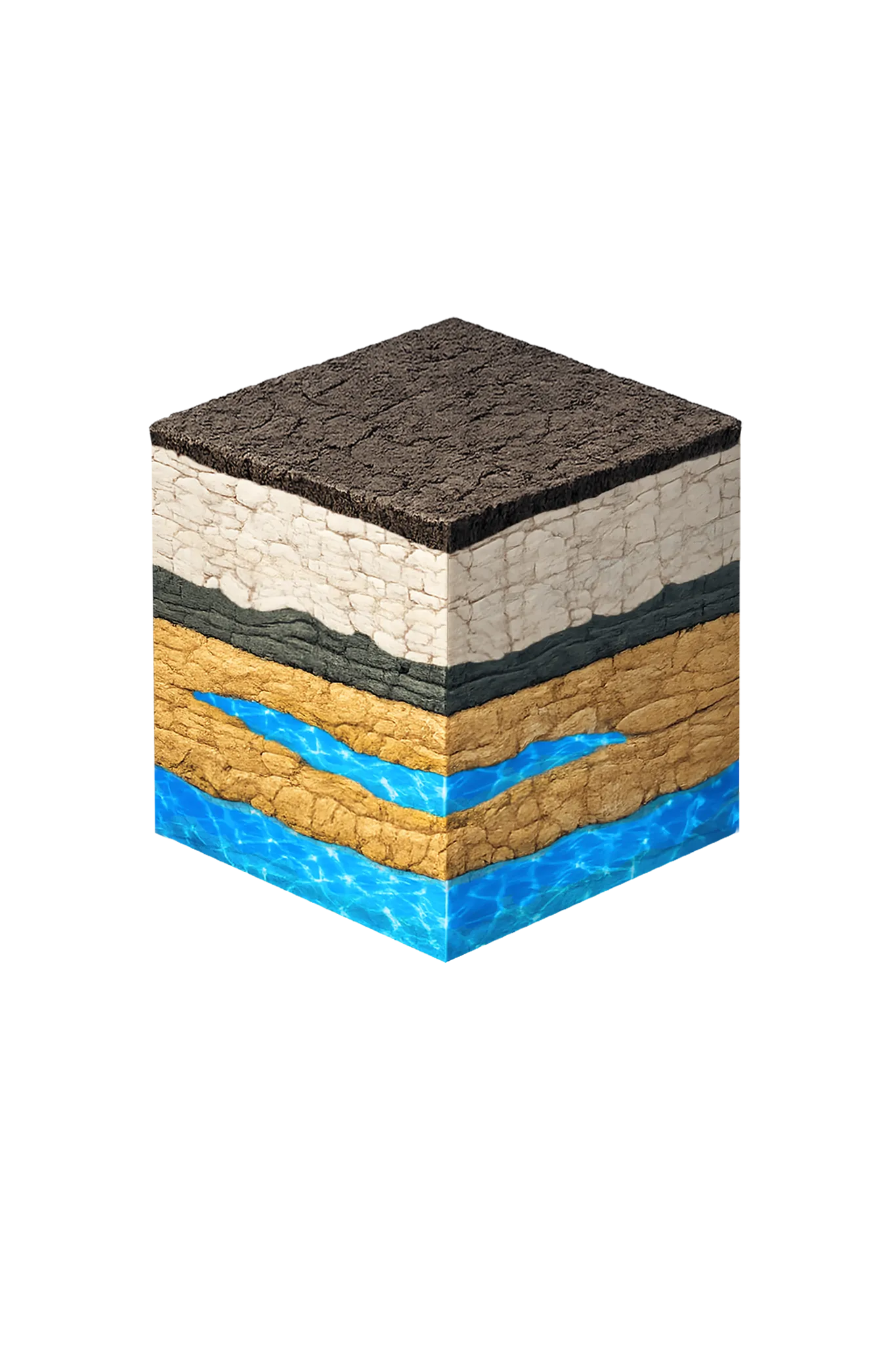
- Topsoil — Blackland Prairie vertisol0–10 ft
- Austin Chalk10–150 ft
- Eagle Ford transition150–200 ft
- Woodbine Formation200–400 ft
Collin County stratigraphy — top to bottom
- Topsoil — Blackland Prairie vertisol
- Dark reddish-brown clay loam that swells when wet and shrinks when dry.
- Austin Chalk
- Austin Chalk — chalk, marl, and limestone forming the upper part of the Upper Cretaceous cover above the Woodbine; low-permeability and not a dependable residential aquifer.
- Eagle Ford transition
- Eagle Ford Shale — dark calcareous shale beneath the Austin Chalk; a confining unit between the chalk and the Woodbine sands, not water-bearing.
- Woodbine Formation
- Sandstone interbedded with shale and clay — three water-bearing zones, the lower two typically developed. The primary aquifer for central and eastern Collin County; water quality degrades eastward toward the Hunt County line.
0–10 ft
10–150 ft
150–200 ft
200–400 ft
Collin County stratigraphy — top to bottom
- Topsoil — Blackland Prairie vertisol (0–10 ft)
- Dark reddish-brown clay loam that swells when wet and shrinks when dry.
- Austin Chalk (10–150 ft)
- Austin Chalk — chalk, marl, and limestone forming the upper part of the Upper Cretaceous cover above the Woodbine; low-permeability and not a dependable residential aquifer.
- Eagle Ford transition (150–200 ft)
- Eagle Ford Shale — dark calcareous shale beneath the Austin Chalk; a confining unit between the chalk and the Woodbine sands, not water-bearing.
- Woodbine Formation (200–400 ft)
- Sandstone interbedded with shale and clay — three water-bearing zones, the lower two typically developed. The primary aquifer for central and eastern Collin County; water quality degrades eastward toward the Hunt County line.
Collin County Quick Facts
- Primary Aquifer
- Woodbine
- Typical Well Depth
- Varies by location
- Groundwater District
- North Texas GCD
- Confinement
- confined
Secondary: Trinity
We estimate from nearby well records
Cities We Serve in Collin County
Anna, TX
Licensed well drilling and pump service in Anna, TX, targeting Collin County's Woodbine and Trinity aquifers; depth varies by parcel.
View Anna details →Celina, TX
Licensed well drilling and pump service in Celina, TX, targeting Collin County's Woodbine and Trinity aquifers; depth varies by parcel.
View Celina details →Princeton, TX
Licensed well drilling and pump service in Princeton, TX, targeting Collin County's Woodbine and Trinity aquifers; depth varies by parcel.
View Princeton details →Prosper, TX
Licensed well drilling and pump service on Prosper acreage lots in Collin County, targeting Woodbine or deeper Trinity formations; depth varies by parcel.
View Prosper details →What's Under Collin County: the Geology Story
Drilling in Collin County means starting in topsoil, working through Surface materials and younger Upper Cretaceous units above the Woodbine, to reach the Woodbine Group / Woodbine Aquifer — the producing zone for most domestic wells.
The full layer-by-layer stratigraphy is laid out under the cube above. Well depth in Collin County varies by property location and overburden thickness; your driller can review TWDB records for neighboring wells to refine the expected completion zone before drilling.
Permits & Regulations in Collin County
Collin County wells are regulated by the North Texas GCD. A pre-drilling permit is required before any new well is constructed. DFW Well Service submits the permit application as part of our drilling process.
Full Collin County permit & regulations →Frequently Asked Questions about Collin County Wells
What aquifer is under Collin County?
How deep are wells typically drilled in Collin County?
Does Collin County require a permit to drill a water well?
What's the main producing formation in Collin County?
Ready to drill or service a well in Collin County?
Most calls answered same business day. Licensed TDLR driller.
Request Well Service or a Drilling Estimate
Tell us a little about your property and what you need help with. We respond within a few hours during business hours.