Planning a well in Parker County?

Water Well Drilling & Service in Parker County, Texas
Parker County sits over the Trinity (Paluxy / Twin Mountains) aquifer system (outcrop in central and western Parker County; confined beneath younger limestone in eastern Parker County). Most residential wells target the Paluxy Formation at 250–550 feet. Drilling is regulated by the Upper Trinity GCD, which requires a pre-drilling permit. Local water quality consideration: Hardness from limestone and iron staining from the Paluxy are the most common concerns countywide.
What’s Under Parker County: a Layer-by-Layer Look
About this diagram
This cross-section shows the actual rock formations beneath Parker County, from topsoil down to the Trinity (Paluxy / Twin Mountains) aquifer system.
Tap any layer in the image, or any layer in the list, to explore each layer and what it means for drilling a well on your property.
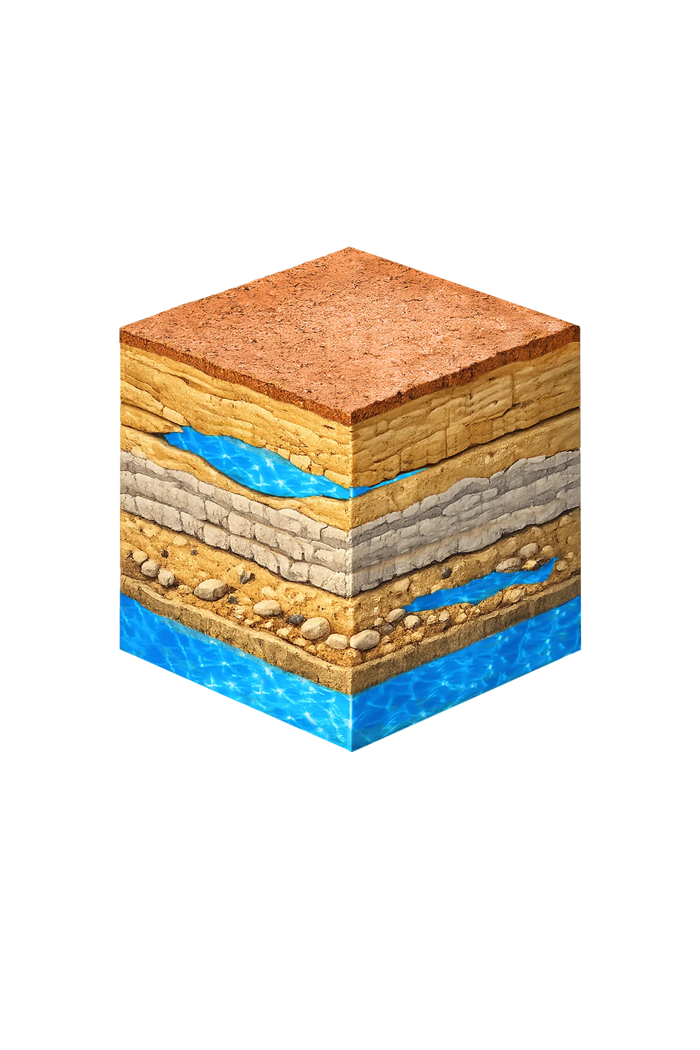

- Topsoil — Cross Timbers Trinity outcrop0–20 ft
- Paluxy Formation20–350 ft
- Glen Rose Formation350–500 ft
- Twin Mountains Formation500–700 ft
Parker County stratigraphy — top to bottom
- Topsoil — Cross Timbers Trinity outcrop
- Thin pale sandy loam with exposed limestone fragments.
- Paluxy Formation
- A buff-to-tan sandstone that sits right at the surface in places, so wells can be shallow here.
- Glen Rose Formation
- Gray dolomitic limestone — mostly a seal between the sands above and below.
- Twin Mountains Formation
- Coarse white-to-tan sand and rounded gravel — the high-yield main producer when a well reaches it.
0–20 ft
20–350 ft
350–500 ft
500–700 ft
Parker County stratigraphy — top to bottom
- Topsoil — Cross Timbers Trinity outcrop (0–20 ft)
- Thin pale sandy loam with exposed limestone fragments.
- Paluxy Formation (20–350 ft)
- A buff-to-tan sandstone that sits right at the surface in places, so wells can be shallow here.
- Glen Rose Formation (350–500 ft)
- Gray dolomitic limestone — mostly a seal between the sands above and below.
- Twin Mountains Formation (500–700 ft)
- Coarse white-to-tan sand and rounded gravel — the high-yield main producer when a well reaches it.
Parker County Quick Facts
- Primary Aquifer
- Trinity (Paluxy / Twin Mountains)
- Typical Well Depth
- 250–550 ft
- Groundwater District
- Upper Trinity GCD
- Confinement
- outcrop in central and western Parker County; confined beneath younger limestone in eastern Parker County
Water Quality Notes
- Hardness from limestone and iron staining from the Paluxy are the most common concerns countywide
- In western Parker County, especially near Millsap, good-quality groundwater can be limited or too mineralized for most uses
- Recommended tests for any well: coliform bacteria, nitrates, iron, hardness, pH, and total dissolved solids
Cities We Serve in Parker County
Aledo, TX
Licensed well drilling, pump repair, and water testing in Aledo, TX, reaching the Trinity aquifer through Parker County's hard limestone.
View Aledo details →Millsap, TX
Licensed well drilling and pump service in Millsap, TX, working through Parker County's limestone to reach the Trinity's Paluxy and Twin Mountains sands.
View Millsap details →Peaster, TX
Licensed well drilling and pump service for farms and rural homes in Peaster and Parker County's hard limestone terrain, reaching the deep Trinity aquifer.
View Peaster details →Springtown, TX
Licensed well drilling and pump service in Springtown, TX, reaching the Parker County Trinity aquifer at typical depths of 250–550 ft.
View Springtown details →Weatherford, TX
DFW Well Service drills and services water wells in Weatherford, TX, reaching the Trinity aquifer through Parker County's limestone formations at 250–550 ft.
View Weatherford details →What's Under Parker County: the Geology Story
Drilling in Parker County means starting in topsoil, working through Paluxy Formation, Glen Rose Formation, to reach the Twin Mountains Formation — the producing zone for most domestic wells.
In parts of Parker County the Trinity sandstone sits remarkably close to the surface. Even so, most wells still drill 250 to 550 feet, because limestone lies between the surface and the productive sand. Both pictures are true at once: the shallow outcrop — where the sand reaches the surface — is the geology, and the deeper drilling depth is the cost reality.
The full layer-by-layer stratigraphy is laid out under the cube above. Well depth in Parker County varies by property location and overburden thickness; your driller can review TWDB records for neighboring wells to refine the expected completion zone before drilling.
Permits & Regulations in Parker County
Parker County wells are regulated by the Upper Trinity GCD. A pre-drilling permit is required before any new well is constructed. DFW Well Service submits the permit application as part of our drilling process.
Full Parker County permit & regulations →Frequently Asked Questions about Parker County Wells
What aquifer is under Parker County?
How deep are wells typically drilled in Parker County?
What water quality issues are common in Parker County wells?
Does Parker County require a permit to drill a water well?
What's the main producing formation in Parker County?
Ready to drill or service a well in Parker County?
Most calls answered same business day. Licensed TDLR driller.
Request Well Service or a Drilling Estimate
Tell us a little about your property and what you need help with. We respond within a few hours during business hours.