Planning a well in Hunt County?
Water Well Drilling & Service in Hunt County, Texas
Hunt County sits over the Nacatoch Sand aquifer system (minor outcrop aquifer — outcrops in a belt from north of Commerce SW through Cash, dips to the SE). Most residential wells target the Nacatoch Sand at 300–650 feet. Hunt County sits outside all groundwater conservation districts — TDLR standards govern. Local water quality consideration: Nacatoch water is alkaline and sodium-rich (sodium-bicarbonate type) — soft rather than hard, unlike the calcium-hard Trinity water in counties to the west.
What’s Under Hunt County: a Layer-by-Layer Look
About this diagram
This cross-section shows the actual rock formations beneath Hunt County, from topsoil down to the Nacatoch Sand aquifer system.
Tap any layer in the image, or any layer in the list, to explore each layer and what it means for drilling a well on your property.
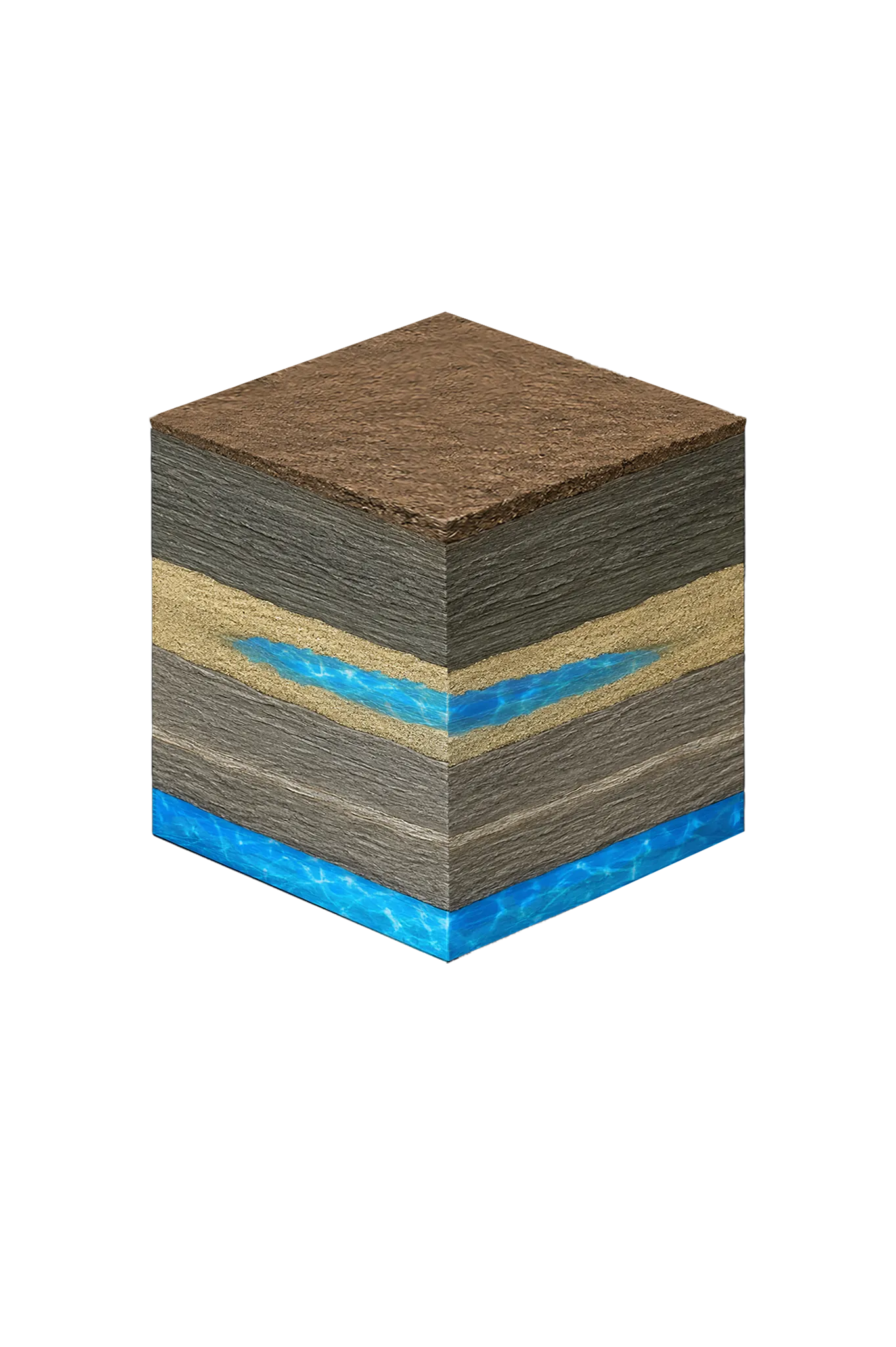
- Topsoil — Blackland margin / Post Oak Savanna sandy loam0–15 ft
- Navarro Group clays and marls (Kemp Clay, Corsicana Marl)15–300 ft
- Nacatoch Sand300–650 ft
- Taylor Group (incl. Wolfe City Sand) / Austin Groupbelow 650 ft
Hunt County stratigraphy — top to bottom
- Topsoil — Blackland margin / Post Oak Savanna sandy loam
- Reddish-brown sandy topsoil over lime-rich prairie clays.
- Navarro Group clays and marls (Kemp Clay, Corsicana Marl)
- A lime-rich clay-and-marl section that seals off water (confining), sitting above the Nacatoch and producing none of its own.
- Nacatoch Sand
- The principal local water source. It reaches the surface (the outcrop) in a belt from north of Commerce southwest through Cash, then dips to the southeast. It holds about 50 ft of freshwater on average and yields small to moderate amounts. The rock is alternating fine quartz sand and mudstone.
- Taylor Group (incl. Wolfe City Sand) / Austin Group
- Below the Nacatoch; not Hunt County household water sources, per TWDB.
0–15 ft
15–300 ft
300–650 ft
below 650 ft
Hunt County stratigraphy — top to bottom
- Topsoil — Blackland margin / Post Oak Savanna sandy loam (0–15 ft)
- Reddish-brown sandy topsoil over lime-rich prairie clays.
- Navarro Group clays and marls (Kemp Clay, Corsicana Marl) (15–300 ft)
- A lime-rich clay-and-marl section that seals off water (confining), sitting above the Nacatoch and producing none of its own.
- Nacatoch Sand (300–650 ft)
- The principal local water source. It reaches the surface (the outcrop) in a belt from north of Commerce southwest through Cash, then dips to the southeast. It holds about 50 ft of freshwater on average and yields small to moderate amounts. The rock is alternating fine quartz sand and mudstone.
- Taylor Group (incl. Wolfe City Sand) / Austin Group (below 650 ft)
- Below the Nacatoch; not Hunt County household water sources, per TWDB.
Hunt County Quick Facts
- Primary Aquifer
- Nacatoch Sand
- Typical Well Depth
- 300–650 ft
- Groundwater District
- No GCD — TDLR standards only
- Confinement
- minor outcrop aquifer — outcrops in a belt from north of Commerce SW through Cash, dips to the SE
Secondary: Woodbine (good water near Celeste only; saline a short distance south)
Water Quality Notes
- Nacatoch water is alkaline and sodium-rich (sodium-bicarbonate type) — soft rather than hard, unlike the calcium-hard Trinity water in counties to the west
- Total dissolved solids (TDS, how mineral-heavy the water is) commonly run 500–1,500 mg/L in the downdip Nacatoch — farther down where the layer tilts deeper — and part of the county has a brackish belt (slightly salty water that needs treatment)
- Iron runs moderate to high and usually needs filtration, and the high sodium makes Nacatoch water poor for landscape irrigation
- The Nacatoch refills very slowly — TWDB estimates effective recharge (how the aquifer refills) at about 0.5% of yearly rainfall on the part that reaches the surface (the outcrop)
City We Serve in Hunt County
What's Under Hunt County: the Geology Story
Drilling in Hunt County means starting in topsoil, working through Navarro Group clays and marls (Kemp Clay, Corsicana Marl), to reach the Nacatoch Sand — the producing zone for most domestic wells.
The full layer-by-layer stratigraphy is laid out under the cube above. Well depth in Hunt County varies by property location and overburden thickness; your driller can review TWDB records for neighboring wells to refine the expected completion zone before drilling.
Permits & Regulations in Hunt County
Hunt County sits outside all groundwater conservation districts. TDLR well construction standards govern, and your driller must be TDLR-licensed.
Full Hunt County permit & regulations →Frequently Asked Questions about Hunt County Wells
What aquifer is under Hunt County?
How deep are wells typically drilled in Hunt County?
What water quality issues are common in Hunt County wells?
Does Hunt County require a permit to drill a water well?
What's the main producing formation in Hunt County?
Ready to drill or service a well in Hunt County?
Most calls answered same business day. Licensed TDLR driller.
Request Well Service or a Drilling Estimate
Tell us a little about your property and what you need help with. We respond within a few hours during business hours.