Planning a well in Navarro County?
Water Well Drilling & Service in Navarro County, Texas
Navarro County sits over the Nacatoch Sand aquifer system (outcrop across central and eastern Navarro County; dips SE at roughly 40–100 ft/mile). Most residential wells target the Nacatoch Sand at 100–800 feet. Navarro County sits outside all groundwater conservation districts — TDLR standards govern. Local water quality consideration: Nacatoch water is alkaline and sodium-rich (sodium-bicarbonate type), so it is soft rather than hard.
What’s Under Navarro County: a Layer-by-Layer Look
About this diagram
This cross-section shows the actual rock formations beneath Navarro County, from topsoil down to the Nacatoch Sand aquifer system.
Tap any layer in the image, or any layer in the list, to explore each layer and what it means for drilling a well on your property.
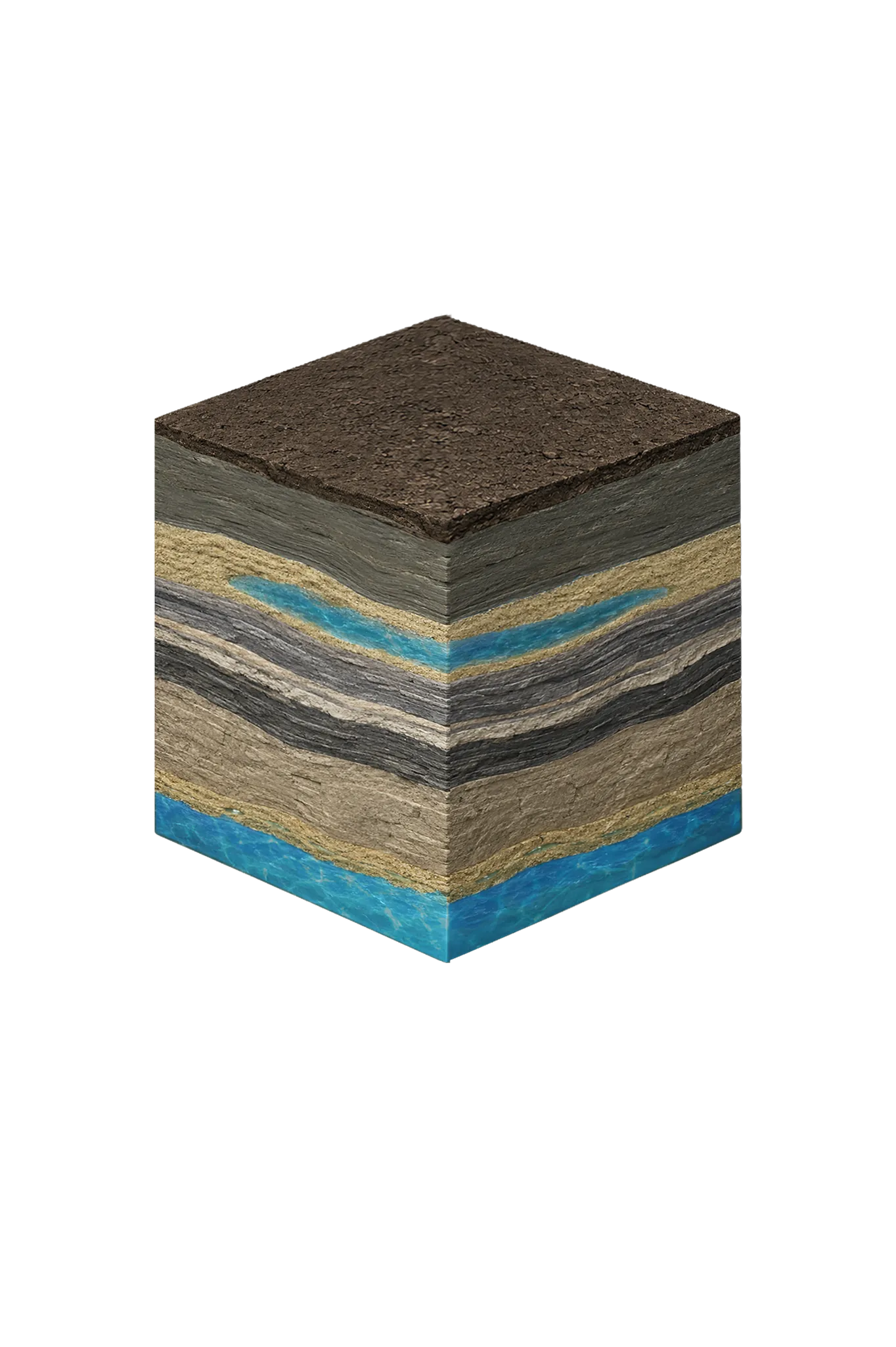
Navarro County stratigraphy — top to bottom
Navarro County stratigraphy — top to bottom
- Topsoil — Blackland Prairie (deep southern extension) (0–15 ft)
- Dark black clay that swells and shrinks with moisture (shrink-swell).
- Navarro Group clays and marls (Corsicana Marl, Kemp Clay) (15–varies)
- Lime-rich clay and marl that produces no usable water. Corsicana is the namesake reference site (type locality) for the whole Navarro Group, and the Corsicana Marl's reference site is about two miles south of the courthouse at the Corsicana Brick Company pit.
- Nacatoch Sand (100–800 (depending on outcrop position) ft)
- The principal local water source. It reaches the surface across central and eastern Navarro County and dips southeast at about 40–100 ft per mile, so depth swings widely — roughly 100 ft near the surface to about 800 ft farther southeast. Around Corsicana, home wells typically run 150–300 ft but yield little, commonly 10–15 gpm.
- Taylor Group / Austin Chalk / Eagle Ford / Woodbine (deep)
- These sit deep below and are not dependable modern home targets in Navarro County.
- Trinity Group (very deep)
- Very deep and brackish (slightly salty, needs treatment); not a home target.
- Carrizo-Wilcox (Carrizo Formation, Wilcox Group) (200–600 (far SE corner only) ft)
- A major aquifer regionally, but it reaches Navarro County only in the far southeast corner near the Freestone and Henderson county lines. In that small area its water is generally better than the Nacatoch.
Navarro County Quick Facts
- Primary Aquifer
- Nacatoch Sand
- Typical Well Depth
- 100–800 ft
- Groundwater District
- No GCD — TDLR standards only
- Confinement
- outcrop across central and eastern Navarro County; dips SE at roughly 40–100 ft/mile
Secondary: Carrizo-Wilcox (far SE corner of the county only)
Water Quality Notes
- Nacatoch water is alkaline and sodium-rich (sodium-bicarbonate type), so it is soft rather than hard
- Total dissolved solids (TDS, how mineral-heavy water is) commonly run 500–1,500 mg/L, rising as the layer dips deeper (downdip) toward the southeast
- Sulfate and chloride vary across the county, and some older test wells showed heavy mineralization
- The county's long oil-and-gas history makes hydrocarbon testing prudent for any new well
- In the far southeast near the Freestone and Henderson county lines, water from the Carrizo-Wilcox where it surfaces (its outcrop) is generally better than the Nacatoch, though iron and manganese can run high locally
City We Serve in Navarro County
What's Under Navarro County: the Geology Story
Drilling in Navarro County means starting in topsoil, working through Navarro Group clays and marls (Corsicana Marl, Kemp Clay), to reach the Nacatoch Sand — the producing zone for most domestic wells.
The full layer-by-layer stratigraphy is laid out under the cube above. Well depth in Navarro County varies by property location and overburden thickness; your driller can review TWDB records for neighboring wells to refine the expected completion zone before drilling.
Permits & Regulations in Navarro County
Navarro County sits outside all groundwater conservation districts. TDLR well construction standards govern, and your driller must be TDLR-licensed.
Full Navarro County permit & regulations →Frequently Asked Questions about Navarro County Wells
What aquifer is under Navarro County?
How deep are wells typically drilled in Navarro County?
What water quality issues are common in Navarro County wells?
Does Navarro County require a permit to drill a water well?
What's the main producing formation in Navarro County?
Ready to drill or service a well in Navarro County?
Most calls answered same business day. Licensed TDLR driller.
Request Well Service or a Drilling Estimate
Tell us a little about your property and what you need help with. We respond within a few hours during business hours.