Erath County Water Well Regulations & Permit Requirements, TX
Quick Answer
Erath County is in the Middle Trinity GCD. Domestic/livestock wells on tracts over 10 acres producing under 25,000 gpd are exempt, but all wells must register.
Planning a well in Erath County?
Erath County sits at the headwaters of the Bosque and Leon Rivers in west-central Texas, on or near the Trinity aquifer outcrop. The Stephenville and Dublin areas are where most domestic and ranch wells are completed. Whether you are drilling a new home well, a livestock supply, or replacing a failing system, your regulatory starting point is the Middle Trinity Groundwater Conservation District.
Which GCD Governs Erath County?
Erath County is fully within the Middle Trinity Groundwater Conservation District (MTGCD), headquartered in Stephenville. MTGCD covers four counties: Bosque, Comanche, Coryell, and Erath. The district was created in 2001 by HB 3665 of the 77th Texas Legislature and operates under Texas Water Code Chapter 36. MTGCD’s current rules were originally adopted May 11, 2004 and were last amended November 13, 2025.
Permit Process Step-by-Step
| Step | Action | Who Is Responsible |
|---|---|---|
| 1 | Hire a TDLR-licensed water well driller | Property owner |
| 2 | Submit MTGCD Well Registration Form under Rule 5.1 — required for every well, exempt or not | Licensed driller |
| 3 | Submit Operating Permit Application under Rule 5.4 if the well will pump more than 17 gpm, or if the tract is 10 acres or less and not platted before May 11, 2004; pay $200 refundable deposit | Licensed driller |
| 4 | Receive MTGCD approval before drilling begins | MTGCD |
| 5 | Drill in compliance with permit and Rule 7.4 spacing requirements | Licensed driller |
| 6 | File state driller’s report with TDLR within 60 days of completion | Licensed driller |
| 7 | If metered, submit monthly readings and annual pumpage report by February 1 (Rule 13.5) | Property owner / operator |
Exempt vs. Non-Exempt Wells in Erath County
MTGCD’s exempt well rule is structured differently from the Upper Trinity, Northern Trinity, and Prairielands districts to the north and east. Under Rule 5.4:
- Domestic, livestock, and poultry wells on tracts larger than 10 acres that are incapable of producing more than 25,000 gallons per day are excluded from operating permit requirements.
- On tracts of 10 acres or less, the same exemption applies only if the tract was platted before May 11, 2004 (the date MTGCD rules took effect for Erath County and Comanche counties) and has not been further subdivided after that date.
Two things to keep straight:
- Exempt does not mean unregistered. Every well in MTGCD — exempt or not — must be registered under Rule 5.1.
- MTGCD operationalizes the rule through its Permits and Forms page: if your well is estimated to pump more than 17 gpm, you need an Operating Permit Application regardless of tract size. This is MTGCD’s own threshold and is distinct from the 17.36 gpm capacity-based exempt rules used by GCDs to the north.
Non-exempt wells (commercial, irrigation, retail public utility, or high-volume production) are also subject to MTGCD production limits under Rule 3.2: 3 acre-feet per contiguous acre per year for non-retail public utilities, with retail public utilities allowed up to 6 acre-feet per contiguous acre per year when Rule 7.4(a) and (d) spacing conditions are met.
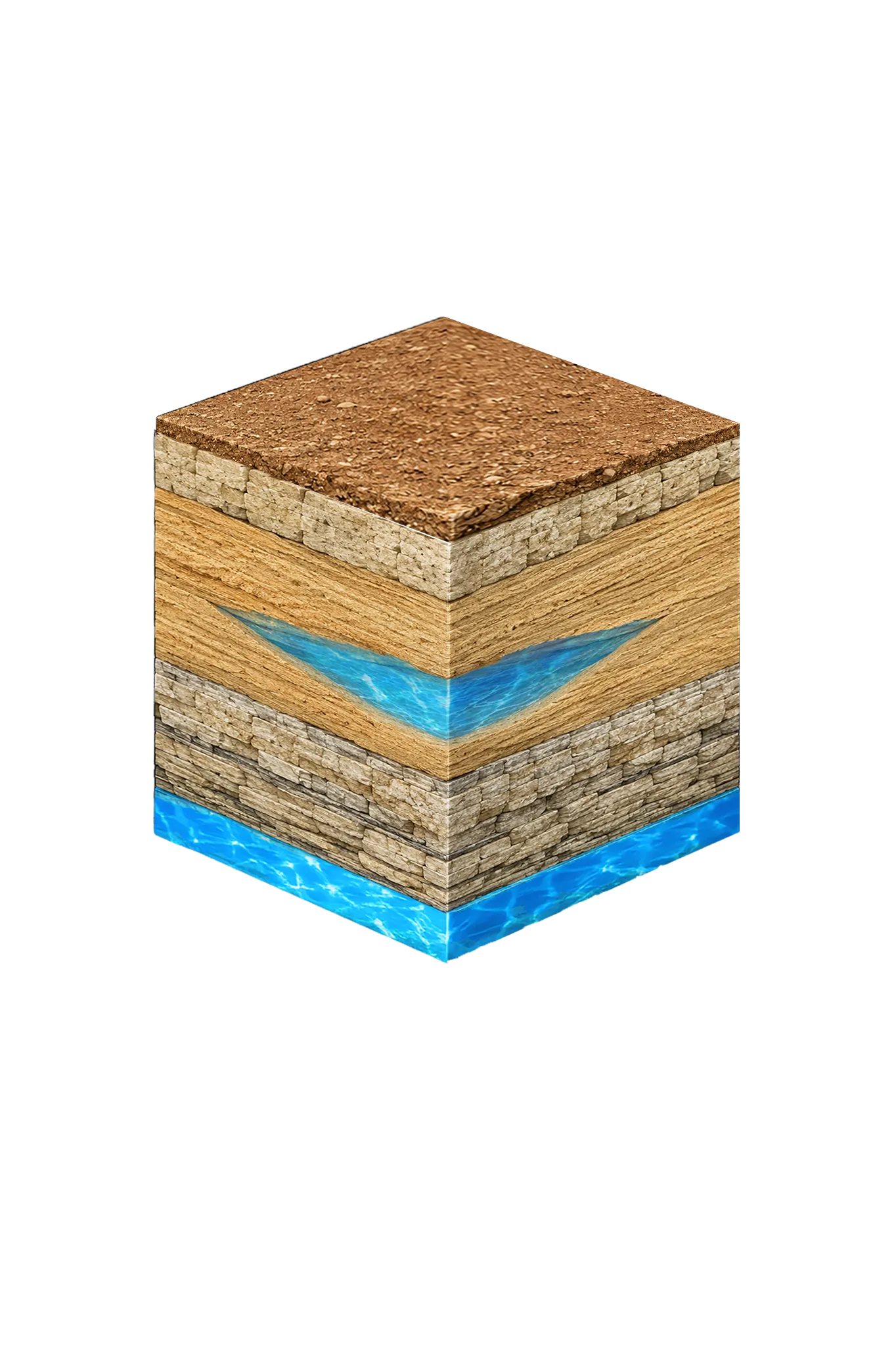
Erath County Geology & Typical Well Depths
Erath County is a Trinity outcrop and near-outcrop county. Wells generally target the Trinity aquifer, which here includes Paluxy, Glen Rose, and Twin Mountains, plus the Travis Peak members (Hensell, Pearsall, Hosston) and the Antlers Formation where the Glen Rose thins and the Paluxy and Twin Mountains coalesce. MTGCD’s planning tables and TWDB monitoring records use different naming conventions for the same rock — your driller and the MTGCD permit may refer to the same interval as “Twin Mountains” in TWDB Water Data and “Twin Mountains (Pearsall/Hosston)” in MTGCD’s monitor well records.
The verified anchor for Erath County depth is the TWDB monitor well south of Stephenville on US Highway 281 (TWDB well 3155504), which is 332 feet deep, completed in Twin Mountains, unconfined, with a continuous water-level record since February 2000. Actual residential well depths vary by location relative to the Glen Rose pinch-out, target Trinity subdivision, casing design, and the driller’s findings on your parcel. Ask your driller to pull nearby TDLR-submitted driller logs before quoting depth.
Well Spacing in Erath County
MTGCD applies two layers of spacing:
- Rule 7.3 requires all new exempt or non-exempt wells to comply with 16 TAC §76.100 state location and completion requirements (separations from septic systems, livestock yards, surface contamination sources, and so on).
- Rule 7.4 sets Operating Permit spacing tiered by casing diameter:
| Casing diameter | Minimum spacing from existing wells |
|---|---|
| Up to 4 inches | 300 ft |
| Over 4 to 5 inches | 400 ft |
| Over 5 to 6 inches | 500 ft |
| Over 6 to 7 inches | 600 ft |
| Over 7 to under 8 inches | 700 ft |
| 8 to under 10 inches | 800 ft |
| 10 inches or greater | 1,000 ft |
Retail public utility higher-production wells must also sit at least 500 feet from property lines.
Reporting Requirements
- All wells: register under Rule 5.1 before drilling.
- Exempt wells covered by Rule 5.4(a)(3) and (4): monthly production reports due by the 5th day of each month.
- Metered wells (Rule 13.5): monthly meter readings or logs; annual pumpage and transport information furnished no later than February 1.
- Transported groundwater (Rule 12.1): annual transport reporting by January 15; transport fee currently authorized up to $0.20 per 1,000 gallons, with the maximum allowable rate increasing 3 percent each calendar year starting January 1, 2024, if approved by the Board after public hearing.
Fees
An Operating Permit Application carries a $200 refundable deposit at submission, refunded within 30 days of MTGCD’s receipt of the state driller’s report. Under Rule 11.6, applications will not be accepted until applicable fees established by Board resolution are received. MTGCD’s current full fee schedule is published on middletrinitygcd.org — check the Permits and Forms page for the current numbers before submitting.
Working With a Licensed Driller
All water wells in Texas must be drilled by a contractor holding a valid TDLR Water Well Driller license. In Erath County, experience with the Trinity aquifer and with MTGCD’s registration and permit forms matters. An experienced driller will review TWDB well logs near your parcel, assess likely depth and yield, handle the MTGCD registration (and the Operating Permit Application if your well is non-exempt or your tract is 10 acres or less), and file the state driller’s report with TDLR after completion.
DFW Well Service (TDLR License #61234 DKMPW) is available to drill throughout Erath County — from Stephenville and Dublin to the rural Bosque River and Leon River corridors. Call us at (940) 536-8560 to discuss your property and get a site-specific estimate.
Erath County sits in the geographic transition between north-central Texas Trinity naming and Hill Country Travis Peak naming. The MTGCD process is straightforward once you know whether your tract qualifies for the Rule 5.4 exemption and which spacing tier applies to your casing diameter. Start there, register every well, and confirm current fees on middletrinitygcd.org before applying.