Palo Pinto County Water Well Regulations & Permit Requirements, TX
Quick Answer
Palo Pinto County has no GCD — earlier sources placing it in Upper Trinity GCD are wrong. Local aquifer is the Cross Timbers Aquifer, not the Trinity.
If you’ve seen Palo Pinto, or Mineral Wells, described as being in the Upper Trinity GCD, that is incorrect — Palo Pinto County has no Groundwater Conservation District at all. It’s also not a Trinity county in any practical sense; the Trinity is largely eroded away here. Your local groundwater comes from Pennsylvanian-age sandstone, conglomerate, and fractured limestone, and yields vary a lot from one tract to the next. Before you budget for a well, talk to a licensed driller and review nearby well logs, because dry holes are a real possibility in the tighter shale areas.
Which GCD Governs Palo Pinto County?
None. Palo Pinto County has no Groundwater Conservation District, so there is no local district to issue permits, set well-spacing rules, cap pumping, or require production reporting.
Wells in Palo Pinto County are regulated only by TDLR (driller and pump-installer licensure under Texas Occupations Code Chapters 1901 and 1902, and 16 Texas Administrative Code Chapter 76) and the default rules of Texas Water Code Chapter 36. No local permit, spacing rule, fee, or production-reporting requirement applies. TCEQ’s March 2026 statewide GCD map confirms Palo Pinto County remains outside any GCD.
One point that is often confused: Palo Pinto County borders Parker County (Upper Trinity GCD) and Erath County (Middle Trinity GCD), but Palo Pinto itself is in neither. The Upper Trinity GCD’s jurisdiction stops at the Parker–Palo Pinto county line. There is one local rule worth knowing — Palo Pinto County adopted a 2021 amendment to its subdivision regulations requiring groundwater-availability certification for new subdivision and development review under Local Government Code Section 232.0032. That affects platting and development review, not every existing rural tract.
What that means for you as a property owner
A Palo Pinto County property owner has no local district to impose well spacing, pumping limits, or drought curtailment, and has no local-district avenue to challenge a neighbor’s pumping. Texas common law applies, including the rule of capture. State well-construction standards still apply.
Step-by-Step: Drilling a Well in Palo Pinto County
| Step | Action | Who Is Responsible |
|---|---|---|
| 1 | Hire a TDLR-licensed water well driller and review nearby well logs first | Property owner |
| 2 | Confirm well siting and construction meet TDLR standards (16 TAC Chapter 76) | Licensed driller |
| 3 | If platting a new subdivision, check the county’s groundwater-availability certification requirement | Property owner |
| 4 | Drill the well — no GCD permit or pre-drilling approval is required in Palo Pinto County | Licensed driller |
| 5 | File the State of Texas Well Report with TDLR within 60 days of completion | Licensed driller |
| 6 | Test water quality before relying on the well | Property owner |
There is no GCD permit step because there is no district. The state well report is still required statewide and is filed by your driller.
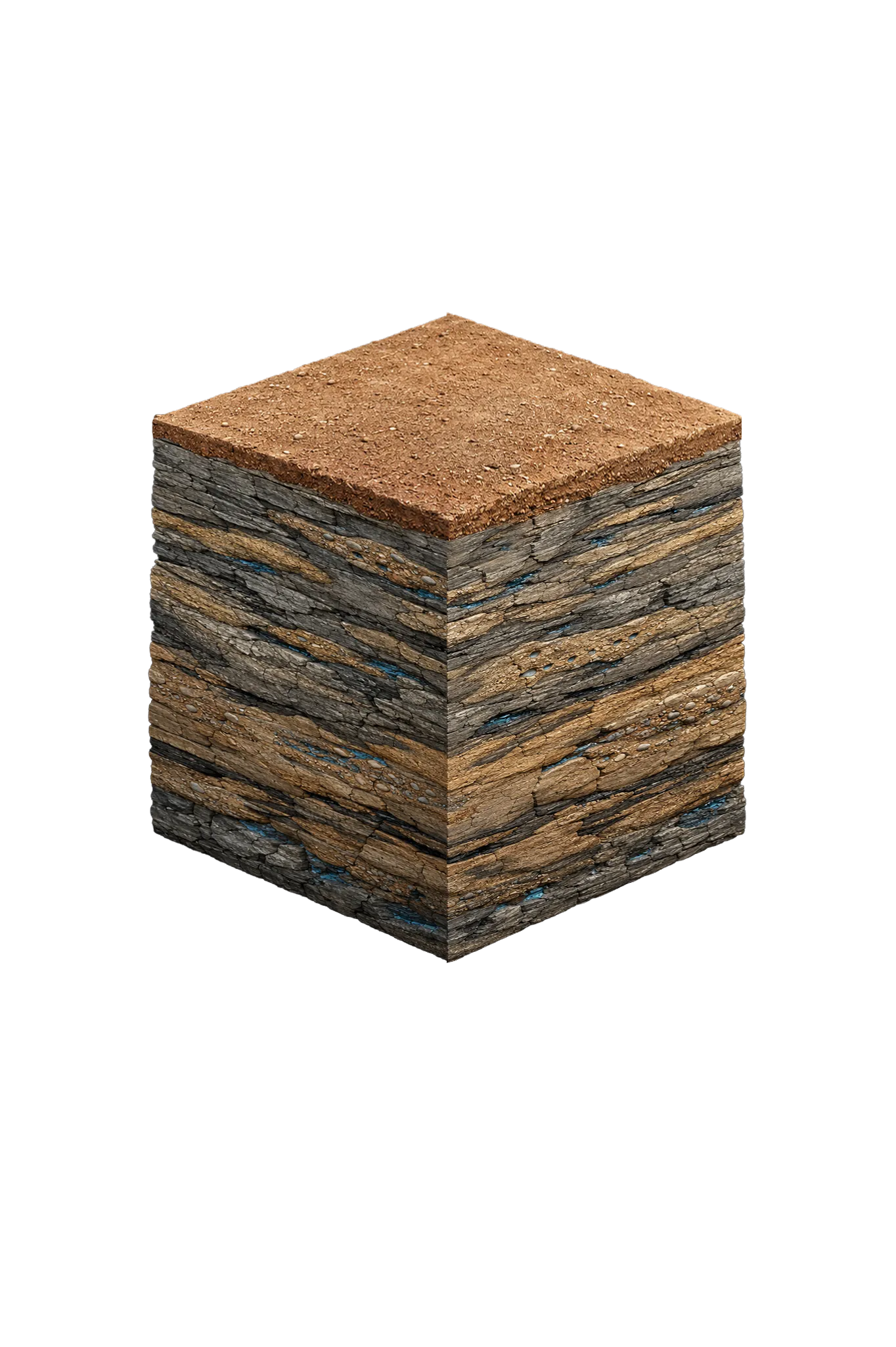
Palo Pinto County Geology & Typical Well Depths
Palo Pinto County sits in the Western Cross Timbers on Pennsylvanian-age bedrock — older than the Cretaceous Trinity that dominates most of the region. The local aquifer is the Cross Timbers Aquifer, made up of Pennsylvanian rock (the Strawn and Canyon groups in this county). Water is found in localized sandstone, conglomerate, fractured limestone, and lens-shaped sand bodies rather than in one continuous formation, so productivity is patchy.
| Formation | Depth in Palo Pinto County | Role |
|---|---|---|
| Quaternary alluvium | Roughly 20–80 ft, along the Brazos River and Palo Pinto Creek | Shallow, variable yield, drought- and contamination-sensitive; site-specific |
| Cross Timbers Aquifer — Canyon Group | Roughly 100–450 ft | Fractured limestone and localized sandstone lenses; wells median ~160 ft, yields often under 20 gpm |
| Cross Timbers Aquifer — Strawn Group | Similar residential depths | Sandstone and conglomerate water-bearing zones; wells median ~120 ft, yields typically under 45 gpm |
| Trinity remnant | Far eastern edge only (where present, ~400–800 ft) | Thin, eroded, often brackish; not a routine residential target |
A reasonable planning range for typical Palo Pinto County residential wells is roughly 100–450 feet, but yields are usually modest and dry holes are reported in areas dominated by tight shales. Because the Pennsylvanian rock dips to the west-northwest, depths vary significantly by location, and western Palo Pinto County sits deeper in the section than the eastern part of the county. Treat the depth range as planning context, not a guarantee for any specific tract.
A note about Mineral Wells: the town’s famous “crazy water” comes from the Brazos River Conglomerate Member of the Garner Formation, and historical mineral-water wells were drilled to depths of about 154 to 383 feet, producing highly mineralized water. That commercial mineral water, still sold today by the Famous Mineral Water Company, is a separate thing from both ordinary household well water and the modern municipal supply.
Why Palo Pinto Wells Can Be Drought-Sensitive
The Cross Timbers Aquifer recharges slowly. The Pennsylvanian limestones and shales have very low primary porosity, so recharge depends on fractures and bedding planes — TWDB estimates only about 0.05 to 0.15 inches per year, roughly a third of a percent of annual rainfall. Most rain runs off into surface reservoirs like Lake Palo Pinto rather than soaking into the bedrock. The practical result is that Palo Pinto County wells can be more drought-sensitive than wells in larger, more continuous aquifers.
Where Your Water Actually Comes From
For most Palo Pinto County properties, the realistic water source is treated surface water. The Palo Pinto County Municipal Water District No. 1 holds the water rights to Lake Palo Pinto and operates the treatment facilities for Mineral Wells. The district has stated plainly that the lack of a significant aquifer system is the main reason groundwater is not a viable option for municipal-scale supply. A major drought-resiliency project, the Turkey Peak Reservoir downstream of Lake Palo Pinto, is funded and under construction, with completion expected in the late 2020s.
Water Quality You Should Expect
Cross Timbers groundwater quality is highly variable. Most sampled wells are fresh to slightly saline, with a median total dissolved solids around 839 mg/L, but chloride in the Cross Timbers tends to run about twice what’s typical in Trinity wells. Water can be hard with elevated iron and manganese. Wells tapping the Strawn Group can occasionally encounter stray gas or methane, given the region’s oil-and-gas-bearing formations, so testing is recommended. Any thin Trinity remnant on the far eastern edge tends to be brackish.
After drilling, test for coliform bacteria, nitrates, total dissolved solids, chloride, hardness, iron, and manganese, and have the driller check for stray gas if completing in the Strawn Group. Test before purchasing any treatment equipment.