Need well service in Decatur?

DFW Well Service helps property owners with water well drilling, pump service, inspections, and related well issues across North Texas.

Welcome to Decatur, TX — DFW Well Service serves Decatur and Wise County

Water Well Drilling & Pump Repair in Decatur, TX | DFW Well Service

Service Area Overview

Licensed well drilling and pump service throughout Decatur, TX, reaching the Trinity aquifer's Antlers Formation in central Wise County.

Services We Provide in Decatur

DFW Well Service (TDLR License #61234 DKMPW) is a licensed water well contractor serving Decatur and Wise County with residential, agricultural, and commercial well services.

Well Depth & Geology in Decatur Area

Isometric geological cross-section cube illustration showing Wise County, Texas stratigraphy — Topsoil, Alluvial deposits (localized along major drainages), Comanche Peak / Walnut limestone cap, Paluxy Formation (southern Wise County) / upper Antlers (central and northern Wise County), Glen Rose Formation (eastern Wise County only), Twin Mountains Formation (southern Wise County) / lower Antlers (central and northern Wise County), and the Trinity (Antlers — Paluxy/Twin Mountains coalescence in central/northern Wise County; Paluxy/Glen Rose/Twin Mountains stack in southern Wise County) aquifer at the base.

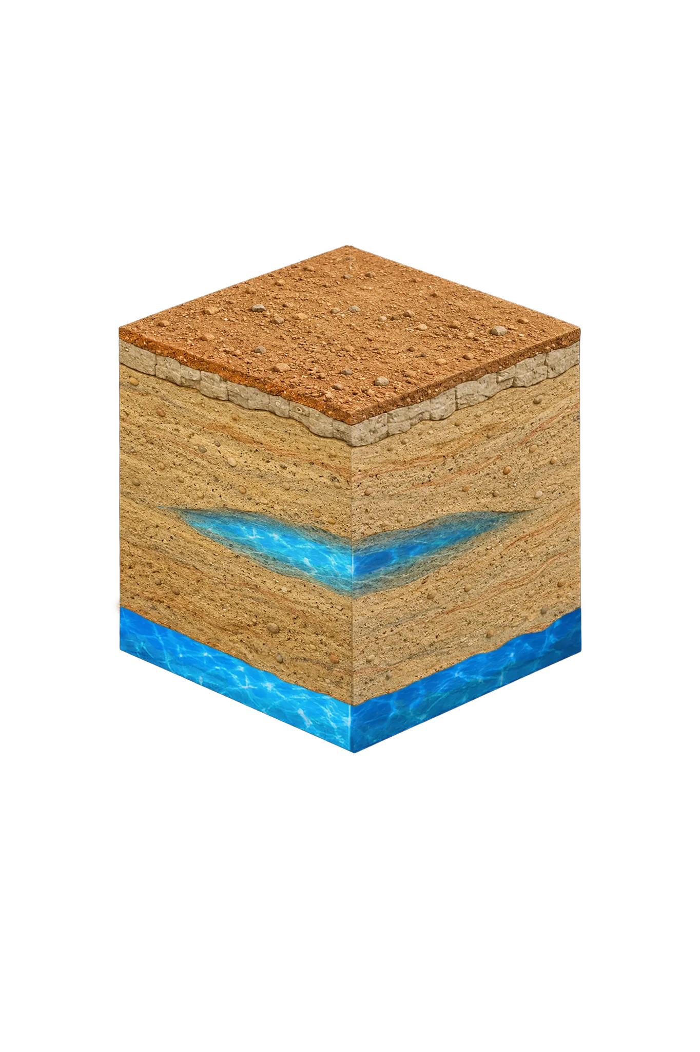
Tap any layer in the cube — or in the list below — to see what it is and what it means for drilling a well here.

  1. Topsoil — West Cross Timbers
    0–20 ft
  2. Antlers Formation
    outcrop / shallow confined — varies
Tap or hover a layer in the cube to see what's beneath the surface here.

This cross-section shows the layer stack typical of Wise County. The exact formations and depths under a specific Decatur-area property vary — see the details above.

Explore the full Wise County geology →

Primary Aquifer
Trinity (Antlers — Paluxy/Twin Mountains coalescence in central/northern Wise County; Paluxy/Glen Rose/Twin Mountains stack in southern Wise County)

Secondary: Cross Timbers Aquifer (Pennsylvanian/Permian — significant in west-central Wise County)

Typical Well Depth
Varies by location

We estimate from nearby well records

Groundwater District
Upper Trinity GCD
Confinement
outcrop / shallow confined — Wise County sits on the geological boundary line where the Glen Rose Formation thins to extinction

Wise County overview → Permit & regulations → TDLR License #61234 DKMPW Updated June 4, 2026

Wells around Decatur draw from the Trinity aquifer, and central Wise County is geologically distinctive in how those layers stack. This is where the Glen Rose Limestone — the thick limestone layer found across most of the region’s Trinity outcrop — thins out to nothing. With the Glen Rose gone, the Paluxy and Twin Mountains sands merge into one body known as the Antlers Formation, the main producing zone for Decatur-area wells. In practice that often means cleaner, sandier drilling here than through the layered Glen Rose stack still found in Hood County and southern Wise to the south.

Decatur’s status as Wise County seat means the city itself is served by municipal water, but the surrounding rural county — with its mix of ranches, hobby farms, and rural homesteads — is heavily dependent on private wells. We’re available to serve customers throughout the Decatur area.

Wise County Permit Requirements

Water wells in Wise County fall under the jurisdiction of both TDLR and the Upper Trinity Groundwater Conservation District. The GCD requires a permit before drilling begins and a completion report once the well is finished. Setback requirements from property lines, buildings, and septic systems must also be observed.

For complete details on Wise County well regulations, visit our guide to Wise County water well regulations.

Call DFW Well Service at (940) 536-8560 for a free estimate on well drilling or any well service in the Decatur area. We’re close by and familiar with Wise County’s geology, and we’ll give you a realistic picture of what your project will involve.

Frequently Asked Questions

How deep are water wells in Decatur, TX?
There's no single typical depth around Decatur — it varies meaningfully from one parcel to the next, so we review the driller's logs from neighboring wells before quoting a project. Wells here target the Antlers Formation: in central Wise County the Glen Rose Limestone has pinched out, so the upper Trinity sands merge into one body (the Antlers) instead of the layered Paluxy / Glen Rose / Twin Mountains column found farther south.
What aquifer serves Decatur and Wise County?
Decatur draws on the Trinity aquifer, primarily through the Antlers Formation — the merged Paluxy / Twin Mountains sandstone unit that forms in central and northern Wise County where the Glen Rose Limestone is absent. The Trinity is a regional aquifer that underlies much of north-central Texas and provides reliable yields for residential and agricultural users.
Do I need a permit to drill a well in Wise County?
Yes. Wells in Wise County require permits from TDLR and the Upper Trinity Groundwater Conservation District. We handle the permit application and all required post-drilling completion reports.
What does well drilling cost near Decatur?
Wise County drilling costs typically run $38–$50 per foot. Final cost depends on completion depth, casing, pump, and pressure equipment. We provide a free itemized written estimate after reviewing neighboring driller's logs for your parcel.
Can you service wells in rural Wise County, not just in Decatur?
Absolutely. We serve all of Wise County, including rural and ranch properties. If you're on a county road outside of Decatur, we still come to you.
How do I know if my well needs rehabilitation vs. replacement?
Well rehabilitation (cleaning, redevelopment, and sometimes chemical treatment) can restore yield and water quality in many cases. If the well casing is corroded, collapsed, or the well is too shallow to reach the aquifer adequately, replacement may be more cost-effective. We'll give you an honest assessment.
Is the well water in Decatur salty or brackish?
Mostly fresh. Decatur's Trinity (the Antlers and Twin Mountains sand) is generally fresh, but the Texas Water Development Board found scattered slightly-salty spots in the deep basal Trinity sand, and the older Cross Timbers rock in far-western Wise County can be mineralized. A total-dissolved-solids test (a measure of how mineral-heavy the water is) is worth it on deep or far-western wells.

Request Service

Tell us about the property and what you need help with.

Fields marked * are required.