Ellis County Water Well Regulations & Permit Requirements, TX
Quick Answer
Ellis County is in the Prairielands GCD. PGCD registration is required for all new wells, including exempt household wells. Most wells are deep downdip.
Ellis County sits between the Trinity outcrop hills to the west and the Blackland Prairie to the east. Most of the county is deep downdip from where the Trinity aquifer reaches the surface, so private wells here are not shallow operations. Whether you are drilling a new well or evaluating an existing one, your regulatory starting point is the Prairielands Groundwater Conservation District.
Which GCD Governs Ellis County?
Ellis County is fully within the Prairielands Groundwater Conservation District (PGCD), which also covers Hill, Johnson, and Somervell Counties. PGCD was created in 2009 by the 81st Texas Legislature under Texas Special District Local Laws Code Chapter 8855. The District’s office is at 208 Kimberly Drive in Cleburne (Johnson County), and its current rules are dated April 21, 2025 and posted at prairielandsgcd.org.
PGCD manages the Trinity aquifer system, the overlying Woodbine, and localized alluvial groundwater across all four of its counties under Texas Water Code Chapter 36.
Permit Process: Step by Step
| Step | Action | Who Is Responsible |
|---|---|---|
| 1 | Hire a TDLR-licensed water well driller | Property owner |
| 2 | Submit PGCD registration (and operating permit application if non-exempt) before drilling | Licensed driller |
| 3 | Receive written approval — do not begin drilling before this | PGCD |
| 4 | Drill the well in compliance with PGCD approval and TDLR standards | Licensed driller |
| 5 | File the state well report with TDLR within 60 days | Licensed driller |
Exempt vs. Non-Exempt Wells in Ellis County
PGCD operates on a capacity-based exempt structure under Rule 2.1, not on the Texas Water Code state default of 25,000 gallons per day.
A household well is exempt from the operating permit, water-use fees, metering, and production reports if its production capacity is 17.36 gpm or less AND it is used solely for domestic, livestock, or poultry purposes.
What “exempt” does not mean:
- Registration is still required. All wells drilled on or after April 1, 2011 must be registered with PGCD before drilling, exempt or not.
- TDLR licensure is still required for the contractor who drills the well.
- The state well report to TDLR is still required, filed by the driller within 60 days of completion.
Non-exempt wells — irrigation at higher capacity, commercial supply, public water systems, and similar uses — must obtain an Operating Permit, install a totalizing non-resettable flow meter, and file Monthly Water Production Reports with PGCD.
Minimum Tract Size and Spacing
For wells drilled or completed after May 15, 2017, PGCD requires a 2-acre minimum tract for the property the well serves. For a single domestic well serving multiple households, that 2-acre minimum is multiplied by the number of households served.
Spacing under Rule 4.3:
- New wells at 17.36 gpm or less must generally be at least 100 feet from existing wells completed in the same aquifer layer and at least 50 feet from the property line.
- New wells over 17.36 gpm must meet calculated spacing limiting drawdown impact at property lines to no more than 10 percent, and must be at least twice that property-line distance from other same-layer wells.
Fees
PGCD’s administrative and water-use fees are set annually by the Board and posted on the District Fees page at prairielandsgcd.org. The fee schedule includes a registration fee for new wells, an operating permit application fee for non-exempt wells, a per-1,000-gallon water-use fee on non-exempt non-agricultural production, a per-acre-foot rate on agricultural use, and a 50% surcharge for groundwater transported outside the District (with retail-public-utility exceptions). Confirm the current rates with your driller from PGCD’s published schedule before applying.
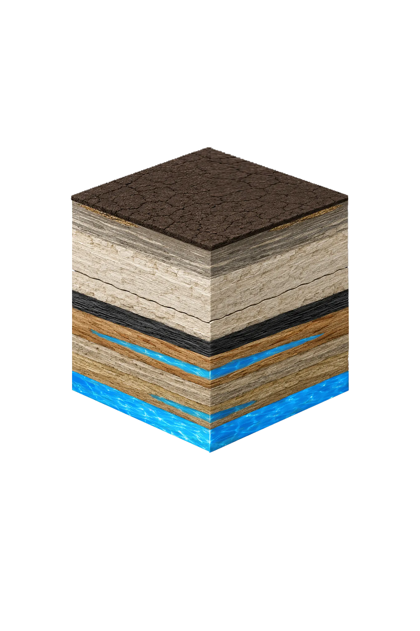
Ellis County Geology and Why Wells Are Deep Here
Ellis County sits well downdip from the Trinity outcrop. The land surface is dominated by Austin Chalk and Eagle Ford bedrock with a thin alluvial cover along major drainages. The Woodbine — a secondary aquifer — sits beneath the Austin Chalk and Eagle Ford and ranges roughly 100 to 1,400 feet deep across the county, with the most often-targeted Woodbine zone at about 600 to 1,000 feet in central Ellis County. Beneath the Washita and Fredericksburg confining units, the Trinity Group’s Paluxy, Glen Rose, Hensell, and Hosston units lie deeper still, with the Twin Mountains basal sand at roughly 2,000 to 3,000 feet.
What that means for your project:
- Drilling is a substantial undertaking in Ellis County compared with shallower Trinity-outcrop counties to the west.
- Depth-to-aquifer is not uniform. Midlothian and northwest Ellis County are closer to recharge areas. Ennis and southeast Ellis County are farther downdip and face greater depth and more mineralization.
- Many Ellis County properties rely on municipal water rather than private wells. If you are weighing a new well against connecting to a public supply, get a depth estimate from a licensed driller working from nearby TDLR submitted well reports before deciding.
Working With a Licensed Driller
All water wells in Texas must be drilled by a contractor holding a valid TDLR Water Well Driller license. In Ellis County, an experienced driller will pull TDLR submitted well reports for the immediate area, estimate likely depth from the regional Trinity and Woodbine pattern at your location, handle PGCD registration and any required operating permit, and design a casing and pump system suited to a deeper well in a moderately mineralized aquifer.
DFW Well Service is licensed to drill throughout Ellis County — from Midlothian and Waxahachie to Ennis and the southern county line. Call us at (940) 536-8560 to discuss your property and get a site-specific estimate.