Need well service in Argyle?

DFW Well Service helps property owners with water well drilling, pump service, inspections, and related well issues across North Texas.

Welcome to Argyle, TX — DFW Well Service serves Argyle and Denton County

Water Well Drilling & Pump Repair in Argyle, TX | DFW Well Service

Service Area Overview

Licensed well drilling and pump service on Argyle acreage properties in Denton County, reaching the Trinity aquifer's Paluxy and Twin Mountains sands.

DFW Well Service provides water well drilling, pump repair, and inspection services throughout Argyle and the surrounding Denton County acreage corridor. Argyle is one of the fastest-growing affluent communities in North Texas, known for its horse properties, large lots, and rural character just 30 miles north of Fort Worth. Many of those acreage estates rely on private water wells — and keeping those wells performing is our business.

Services We Provide in Argyle

Well Depth & Geology in the Argyle Area

Isometric geological cross-section cube illustration showing Denton County, Texas stratigraphy — Topsoil, Local alluvium (Elm Fork of the Trinity, Ray Roberts and Lewisville lake margins), Woodbine Aquifer (eastern Denton County), Washita and Fredericksburg Groups, Paluxy Formation (Trinity upper unit), Glen Rose Formation (southern Denton County only), Twin Mountains Formation (southern Denton County) / Antlers Formation (northern Denton County), and the Trinity (Paluxy / Glen Rose / Twin Mountains; Antlers in northern Denton County) aquifer at the base.

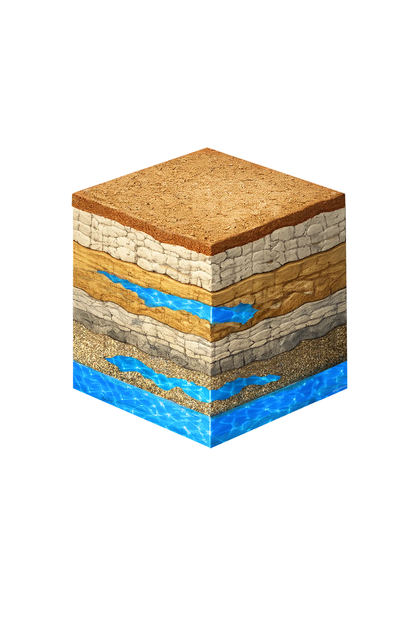
Tap any layer in the cube — or in the list below — to see what it is and what it means for drilling a well here.

  1. Topsoil — Cross Timbers transition
    0–15 ft
  2. Comanche Peak / Walnut limestone
    15–80 ft
  3. Paluxy Formation
    80–250 ft
  4. Glen Rose Formation
    250–350 ft
  5. Twin Mountains Formation
    350–450 ft
Tap or hover a layer in the cube to see what's beneath the surface here.

This cross-section shows the layer stack typical of Denton County. The exact formations and depths under a specific Argyle-area property vary — see the details above.

Explore the full Denton County geology →

Primary Aquifer
Trinity (Paluxy / Glen Rose / Twin Mountains; Antlers in northern Denton County)

Secondary: Woodbine (eastern Denton County)

Typical Well Depth
Varies by location

We estimate from nearby well records

Groundwater District
North Texas GCD
Confinement
confined; outcrop in far western Denton County

Denton County overview → Permit & regulations → TDLR License #61234 DKMPW Updated June 4, 2026

Wells around Argyle draw from the Trinity aquifer, the primary residential water source in this southwestern corner of Denton County. Most domestic wells here complete in the upper Paluxy sand or the deeper Twin Mountains sand. Between those two sits the Glen Rose Formation — mostly solid limestone that holds little water, so a well is cased through it to reach the sand below rather than producing from it. The Woodbine, a shallower layer, is a minor secondary target on some Denton County parcels. Depth varies meaningfully from one parcel to the next, so there’s no single typical figure for the county.

Drilling rates in Denton County typically run $38–$50 per foot. Mixed formations and occasional hard limestone can affect total project cost.

Denton County Permit Requirements

New wells in Denton County are regulated by the North Texas Groundwater Conservation District. A pre-drilling permit is required for all new well construction, including exempt domestic wells. For full details on the county process, see our guide to Denton County water well regulations.

DFW Well Service (TDLR License #61234 DKMPW) has worked on acreage properties throughout the Argyle area. Call us at (940) 536-8560 for a free estimate on new well drilling or pump service.

Frequently Asked Questions

Why do many Argyle properties use private wells?
Argyle attracts buyers seeking large-lot acreage properties outside dense suburban development. Many of these tracts — particularly those on the rural outskirts — are not served by municipal water lines, making private wells the standard water source. Acreage estates of five acres or more frequently depend on a dedicated water well.
How deep are wells in the Argyle area of Denton County?
Depth varies meaningfully from one Argyle parcel to the next, so there's no single typical figure — we review the driller's logs from neighboring wells before quoting a depth for your property. Most domestic wells here complete in the Trinity aquifer's Paluxy and Twin Mountains sands, and how deep that sand sits changes across short distances. Longer term, the district projects the water level in the deeper Twin Mountains sand under Denton County to drop several hundred feet, which is worth designing the well around.
Which GCD covers wells in Argyle?
Argyle is in Denton County, which falls under the North Texas Groundwater Conservation District. A pre-drilling permit is required. DFW Well Service submits permit applications on your behalf as part of the drilling process.
What does well drilling cost in Argyle?
Denton County drilling rates typically run $38–$50 per foot. Final cost depends on completion depth, casing, pump, and pressure equipment. We provide a free itemized written estimate after reviewing neighboring driller's logs for your parcel.
Can you inspect a well on a property I'm buying near Argyle?
Yes. We perform well inspections and flow tests for real estate transactions throughout Denton County. A pre-purchase inspection includes a visual assessment of the wellhead, a flow rate test, and a report suitable for your due diligence file.
Do you handle pump replacements in Argyle?
Absolutely. We replace and repair submersible pumps, pressure tanks, and associated electrical systems on existing wells throughout Denton County. If your pump has failed or your water pressure has dropped, call us for a same-day or next-day service visit.
Is the well water in Argyle salty or brackish?
Generally fresh. Argyle draws from the Trinity — and from the Woodbine in eastern Denton County — which the Texas Water Development Board maps as fresh in this area. The water turns slightly salty only farther downdip, meaning farther along where the layer tilts deeper. After drilling, test for total dissolved solids (a measure of how mineral-heavy the water is), sulfate, and iron.

Request Service

Tell us about the property and what you need help with.

Fields marked * are required.